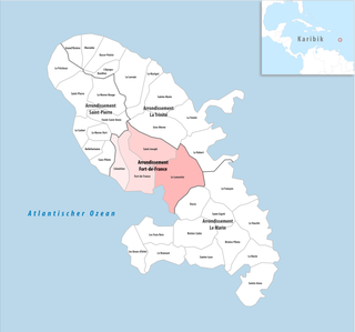
Arrondissement of Fort-de-France
| Arrondissement of Fort-de-France | |
|---|---|
| region | Martinique |
| Department | Martinique |
| prefecture | Fort-de-France |
| Residents | 156,079 (Jan. 1, 2017) |
| Population density | 913 inhabitants / km² |
| surface | 170.99 km² |
| Cantons | 16 |
| Communities | 4th |
| INSEE code | 9721 |
 Location of the Fort-de-France arrondissement in the Martinique department |
|
The Arrondissement Fort-de-France is an administrative unit of the French department of Martinique . The capital ( prefecture ) is Fort-de-France .
On June 1, 1995, the Arrondissement Saint-Pierre was formed from parts of the Arrondissement Fort-de-France .
Population development
| 1967 | 1974 | 1982 | 1990 | 1999 | 2006 |
|---|---|---|---|---|---|
| 139,660 | 147,651 | 155,571 | 163.969 | 166,238 | 168,720 |
Communities
The 4 municipalities of the Arrondissement of Fort-de-France are:
| local community | Residents January 1, 2017 |
Area km² |
Density of population / km² |
Code INSEE |
Post Code |
|---|---|---|---|---|---|
| Fort-de-France | 80.041 | 44.21 | 1,810 | 97209 | 97200, 97234 |
| Le Lamentin | 39,809 | 62.32 | 639 | 97213 | 97232 |
| Saint-Joseph | 16,232 | 43.29 | 375 | 97224 | 97212 |
| Schœlcher | 19,997 | 21.17 | 945 | 97229 | 97233 |
| Arrondissement of Fort-de-France | 156.079 | 170.99 | 913 | 9721 | - |
Cantons
Until 2015, the following 16 cantons existed in the Arrondissement of Fort-de-France :