Arthur River (Blackwood River)
| Arthur River | ||
|
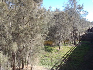
Arthur River from the bridge over the Albany Highway |
||
| Data | ||
| location | Wheatbelt Region , Western Australia | |
| River system | Blackwood River | |
| Drain over | Blackwood River → Indian Ocean | |
| Headwaters | Arthur River Nature Reserve in the Yockrikine Range 33 ° 2 ′ 11 ″ S , 117 ° 25 ′ 53 ″ E |
|
| Source height | 299 m | |
| confluence | with the Balgarup River to the Blackwood River Coordinates: 33 ° 41 ′ 0 ″ S , 116 ° 43 ′ 57 ″ E 33 ° 41 ′ 0 ″ S , 116 ° 43 ′ 57 ″ E |
|
| Mouth height | 215 m | |
| Height difference | 84 m | |
| Bottom slope | 0.6 ‰ | |
| length | 140 km | |
| Catchment area | 28,100 km² | |
| Left tributaries | Buchanan River , Beaufort River , Kojonup Brook | |
| Right tributaries | Yilliminning River , Narrogin Brook, Mookine Creek, Hillman River , Three Mile Gully, Darlinup Gully | |
| Small towns | Piessville, Arthur River, Duranillin | |
| Communities | Moodjarrup | |
The Arthur River is a 140 km long river in the southwest of the Australian state of Western Australia .
geography
The headwaters of the Arthur River is located around 30 km north of Wagin in the Arthur River Nature Reserve, which is in the northern part of the Yockrikine Range .
The river flows in a southwestern direction from its source until it meets the Balgarup River to form the Blackwood River .
Tributaries with mouth heights
- Yilliminning River - 295 m
- Narrogin Brook - 289 m
- Buchanan River - 283 m
- Mookine Creek - 281 m
- Hillman River - 236 m
- Three Mile Gully - 234 m
- Beaufort River - 231 m
- Kojonup Brook - 223 m
- Darlinup Gully - 217 m
See also
Individual evidence
- ↑ a b c d Map of Arthur River, WA . Bonzle.com
- ^ History of River Names - A - Arthur River . Landgate ( Memento from January 22, 2014 in the Internet Archive )
