
Lindesberg
| Lindesberg | ||||||
|
||||||
| State : | Sweden | |||||
| Province (län): | Örebro län | |||||
| Historical Province (landskap): | Vastmanland | |||||
| Municipality : | Lindesberg | |||||
| Coordinates : | 59 ° 36 ' N , 15 ° 14' E | |||||
| SCB code : | 6040 | |||||
| Status: | Crime scene | |||||
| Residents : | 9571 (December 31, 2015) | |||||
| Area : | 8.1 km² | |||||
| Population density : | 1182 inhabitants / km² | |||||
| List of perpetrators in Örebro County | ||||||

Lindesberg is a town in the Swedish province of Örebro län and a typical industrial location in the area that bears the name Bergslagen . The city is about 40 km north of Örebro , has a good 8,700 inhabitants and is the capital of the municipality of the same name . Lake Lindessjön is in the south of the city .
history

The town's first stone church was probably built in the 14th century. Stones from this building can still be found in the choir of the current church. Until the middle of the 17th century the place was called Lindesås . Lindesberg , on the other hand, was the name of the surrounding mining area. In the late Middle Ages , the church village was a central trading center in the region. In connection with the expansion of mining, the place also gained increasing importance.
In 1643 the settlement was given city rights by Queen Christina's guardianship. At the same time the name of the place was changed. The following time was marked by a competition with the city of Arboga , whereby Lindesberg was able to maintain its position as a center for iron trade . After that, the city's development stagnated and around 1770 Lindesberg had 650 inhabitants. Until well into the 19th century, the city's economy was characterized by trade between the Bergslagen area and the neighboring rural plains. The actual expansion took place around 1870 when the place got a railway connection . Many buildings were damaged in the major fires of 1869 and 1894. Even after the spring flood of 1977, when many houses were flooded, the cost of reparations was high. In the 20th century many metalworking factories sprang up and in more recent times the service sector in particular has grown.
Development
The central parts of Lindesberg are still shaped by the development plan from 1644 by defining a right-angled road network. The city fires and the floods led to different building forms made of stone or wood. In the new city map from 1878, it was therefore decided to use green esplanades to prevent the fire from spreading. One example of this is Kristinavägen , which was converted into a wide treeless thoroughfare in 1963. In the last few years linden trees have been planted here again despite the displeasure of some citizens who complained that it was difficult to get ahead.
The narrower Kungsgatan runs parallel to Kristinavägen , and with its wooden houses it is another main shopping street. At the central square, Rådhustorget , is Lindesberg Church, the court house built in 1895, the city hotel and a bank.
photos
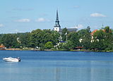
Lindessjön and church

Kungsgatan

railway station

Court (Tingshuset)

Gamla Sundbron

The old pump house

Leda and the swan

Stadthotel (Stadshotellet)


Web links
- Augustibuller (Swedish)
- Lindesberg in Bergslagen (Swedish, English, German)
Footnotes
- ↑ a b Statistiska centralbyrån : Land area per Tatort, folkmängd and invånare per square kilometer. Vart femte år 1960 - 2015 (database query)
Perpetrator: Fellingsbro | Frövi | Gusselby | Lindesberg | Ramsberg | Rockhammar | Storå | Stråssa | Vedevåg
Småorter: Fanthyttan | Lövåsen | Oppboga | Östannor | Östra Löa | Östra Öskevik | Snuggan | Spannarboda | Sundbotorp | Ullersätter | Vanneboda