Auldgirth
| Auldgirth | ||
|---|---|---|
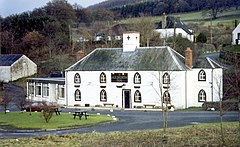
| The Auldgirth Inn | ||
| Coordinates | 55 ° 10 ′ N , 3 ° 42 ′ W | |
|
|
||
| administration | ||
| Post town | DUMFRIES | |
| ZIP code section | DG2 | |
| prefix | 01387 | |
| Part of the country | Scotland | |
| Council area | Dumfries and Galloway | |
| British Parliament | Dumfries and Galloway | |
| Scottish Parliament | Dumfriesshire | |
Auldgirth is a town in the Scottish Council Area Dumfries and Galloway . It is located around 13 kilometers northwest of Dumfries on the left bank of the Nith .
history
In the 1780s, a major crossing of the Nith was created with the Auldgirth Bridge, directly west of the village . Today the bridge is protected as a monument of the highest category A. In the 19th century, Auldgirth had its own post office as well as the way station Auldgirth Inn . About three kilometers south is Ellisland Farm , a farm where the poet Robert Burns once lived. The country estate Blackwood House to the west goes back to a tower house .
traffic
The A76 ( Dumfries - Kilmarnock ) touches Auldgirth and connects the village to the trunk road network. In the 19th century Auldgirth got its own station along the Glasgow and South Western Railway . The station has since been closed.
Individual evidence
- ^ Entry in the Gazetteer for Scotland
- ↑ Listed Building - Entry . In: Historic Scotland .
- ↑ a b Auldgirth in: FH Groome: Ordnance Gazetteer of Scotland: A Survey of Scottish Topography, Statistical, Biographical and Historical. , Grange Publishing, Edinburgh, 1885.
- ↑ Information about the Ellisland Farm
- ↑ Listed Building - Entry . In: Historic Scotland .

