
Nith
| Nith | ||
 The Nith a short distance from the mouth |
||
| Data | ||
| location | East Ayrshire , Dumfries and Galloway , Scotland | |
| River system | Nith | |
| Drain over | Solway Firth → Irish Sea | |
| River basin district | Solway Tweed XRBD | |
| source | On the slopes of Enoch Hill 55 ° 19 ′ 40 ″ N , 4 ° 17 ′ 8 ″ W. |
|
| Source height | 425 m ASL | |
| muzzle | South of Dumfries in the Solway Firth Coordinates: 54 ° 56'59 " N , 3 ° 32'7" W 54 ° 56'59 " N , 3 ° 32'7" W.
|
|
| length | 112 km | |
| Left tributaries | Cample Water , Mennock Water , Crawick Water | |
| Right tributaries | Cluden Water , Kello Water , Afton Water , Euchan Water , Scaur Water | |
The Nith is a river in the Scottish Council Areas East Ayrshire and Dumfries and Galloway and the historic counties of Ayrshire , Kirkcudbrightshire and Dumfriesshire . He is eponymous for the historic province of Nithsdale .
course
The river has its source at a height of 425 m between the crests of Enoch Hill and Prickeny Hill . The source in East Ayrshire is about eight kilometers east of Dalmellington and southwest of New Cumnock . First flowing to the north, the Nith describes a wide semicircle before finally flowing south about ten kilometers south of Dumfries to open into a twelve kilometer long estuary . After 112 km it flows into the Solway Firth , which finally widens into a bay and merges into the Irish Sea .
The Nith flows through numerous localities and a few small towns. The most important are Kirkconnel , Sanquhar , Thornhill , Auldgirth and Dumfries. Francis Groome described the upper reaches of the Nith, which roams a swampy stretch of land, as extremely dreary in the late 19th century. There were no forests or meadows on the banks of the shallow, sluggish river. Only the lower course, lined with various historical buildings, would have scenic charm. Navigating the Nith estuary is tricky for boaters. The regional center Dumfries had an important inland port on the Nith during the industrialization period.
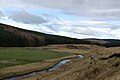
Upper course of the Nith

Estuary of the Nith


Tributaries
The Nith takes on numerous streams along its course. The most important left tributaries include the Cample Water near Thornhill, the Mennock Water near Mennock and the Crawick Water near Sanquhar. From the right lead at the Dumfries Cluden Water in Closeburn the Scaur Water in Sanquhar the Euchan Water in Kelloholm the Kello Water and New Cumnock the Afton Water a.
bridges
With the A75 , the A76 , the A702 , the A756 and the A780, in addition to numerous secondary roads, five trunk roads cross the Nith. Between New Cumnock and Dumfries, the course of the A76 largely follows the river and crosses it several times. Of the numerous bridges spanning the Nith, Thornhill's Nith Bridge , Auldgirth Bridge and Devorgilla Bridge are classified as monuments of the highest Scottish monument category A. The Nith Bridge at New Cumnock in New Cumnock has been classified in Category B.

Nith Bridge from Thornhill (A 702)

Auldgirth Bridge (A76)
_-_geograph.org.uk_-_533035.jpg)


-_Dumfries_-_geograph.org.uk_-_194537.jpg)
Web links
Individual evidence
- ↑ a b c d Nith in: FH Groome: Ordnance Gazetteer of Scotland: A Survey of Scottish Topography, Statistical, Biographical and Historical. , Grange Publishing, Edinburgh, 1885.
- ↑ a b c Entry in the Gazetteer for Scotland
- ↑ Listed Building - Entry . In: Historic Scotland .
- ↑ Listed Building - Entry . In: Historic Scotland .
- ↑ Listed Building - Entry . In: Historic Scotland .
- ↑ Listed Building - Entry . In: Historic Scotland .