
B'nei Shimon
| B'nei Shimon | |||
|---|---|---|---|
| Basic data | |||
| State : |
|
||
| District : | south | ||
| Coordinates : | 31 ° 25 ' N , 34 ° 43' E | ||
| Area : | 440 km² | ||
| Residents : | 7,100 (2010) | ||
| Population density : | 16 inhabitants per km² | ||
| Time zone : | UTC + 2 | ||
| Community type: | Regional administration | ||
|
|||

The B'nei Shimon regional administration ( Hebrew מועצה אזורית בני שמעון Mo'atza Azorit B'nei Schimon ) is an Israeli regional administration . It is named after one of the twelve tribes of Israel , the tribe of Simeon .
location
The B'nei Shimon regional administration is located in the northern Negev , in the southern district .
history
In the area of regional administration, four localities (three kibbutzim and one moshav ) were initially founded as part of the “ 11-point program in the Negev desert ” . Other places were only built after the establishment of the State of Israel . The regional administration was established in 1952.
structure
The regional administration is responsible for:
- 7 kibbutzim : → List of kibbutzim
- 4 moshavim : → table of moshavim
- 1 Community settlement : → Table of community settlements
- 1 Municipal place : Schomria
Residents
The Israeli Central Bureau of Statistics reports the following population figures for the regional administration in the censuses of May 22, 1961, May 19, 1972, June 4, 1983, November 4, 1995 and December 28, 2008:
| Year of the census | 1961 | 1972 | 1983 | 1995 | 2008 * |
| Number of inhabitants | 2,800 | 4,500 | 6,600 | 10,600 | 6,200 * |
In the field of regional administration are about 10,000 nomadic living Bedouins . These were no longer calculated as residents of the regional administration in the 2008 census as they do not have a permanent address.
Source: Israel Central Bureau of Statistics
photos
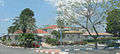
The administration building
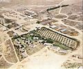
The kibbutz Chatzerim

Individual evidence
- ^ B'nei Shimon ( Hebrew ) Israel Central Bureau of Statistics. Retrieved February 6, 2019.