Baco (Oriental Mindoro)
| Municipality of Baco | ||
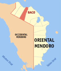
| Location of Baco in the Oriental Mindoro Province | ||
|---|---|---|

|
||
| Basic data | ||
| Region : | MIMARO | |
| Province : | Oriental Mindoro | |
| Barangays : | 27 | |
| District: | 1. District of Oriental Mindoro | |
| PSGC : | 175201000 | |
| Income class : | 4. Income bracket | |
| Households : | 5717 May 1, 2000 census
|
|
| Population : | 37,215 August 1, 2015 census
|
|
| Population density : | 154 inhabitants per km² | |
| Area : | 241.70 km² | |
| Coordinates : | 13 ° 21 ′ N , 121 ° 4 ′ E | |
| Postal code : | 5201 | |
| Mayor : | Graciano P. Dela Chica ( LP ) | |
| Geographical location in the Philippines | ||
|
|
||
Baco is a Filipino municipality in the province of Oriental Mindoro . It has 37,215 inhabitants (August 1, 2015 census).
geography
The municipality of Baco is located in the north of the Oriental Mindoro Province. It is bordered to the east by Calapan City and Naujan , to the south by Santa Cruz and Sablayan in the province of Occidental Mindoro and to the west by San Teodoro . The community is located at the eastern entrance to Isla Verde Strait , which is considered a hot spot of marine biodiversity in the Philippines and worldwide.
Barangays
Baco is politically divided into 27 barangays .
|
|
