
Bahla
Coordinates: 22 ° 58 ' N , 57 ° 18' E

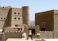
The oasis city of Bahla ( Arabic بهلاء, DMG Bahlāʾ ) is one of the oldest royal cities in Oman . It is located about 180 km south of the capital Muscat at the foot of the Jabal al-Achdar Mountains . It is surrounded by a 12 km long and 5 m high city wall made of adobe bricks . Bahla was the capital of the Nabhani dynasty from the 12th to 17th centuries .
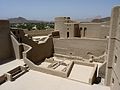
In the middle of the city wall is the fortress Hisn Tamah, probably built in the 17th century by the Nabhani tribe on a stone foundation with unbaked clay bricks and straw . The huge fortress has a total of 15 gates and 132 defense towers. Due to its location above the wadi , it was of great strategic importance.

View over Bahla


Web links
Commons : Bahla - collection of images
- Official website of the Omani Ministry of Information regarding castles and forts ( Memento of November 5, 2013 in the Internet Archive )
- Entry on the UNESCO World Heritage Center website ( English and French ).