Baidara Bay
| Baidara Bay | ||
|---|---|---|
|
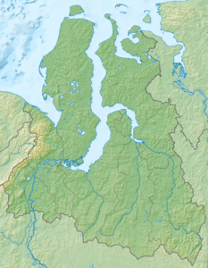
Location of the bay in the Kara Sea |
||
| Waters | Kara Sea | |
| Land mass | Western Siberia | |
| Geographical location | 69 ° 0 ′ N , 67 ° 30 ′ E | |
|
|
||
| width | 78 km | |
| depth | 180 km | |
| Greatest water depth | 27 m | |
| Islands | Lütke, Ngonjarzo, Chaleingo, Lewdijew, Torasawei | |
| Tributaries | Baidarata , Kara , Juribei | |
The Baidarata Bay ( Russian Байдарацкая губа , Baidarazkaja Guba ) is a large bay in the west of the Kara Sea . It lies between the Yamal Peninsula in the east and the Jugor Peninsula in the southwest. Administratively it belongs to the Yamal-Nenets Autonomous Okrug in Russia .
The bay extends from the mouth of the Baidarata River for about 180 km in a north-westerly direction to an imaginary line between the capes Mys Tolstik at the mouth of the Kara and Mys Marre-Salja on a spit of Yamal. At its entrance it reaches its greatest width of 78 km. Here the bay is up to 27 m deep. It has some islands close to the coast, which, with the exception of the up to 40 m high Litke Island, are only a few meters above sea level and all of them are uninhabited. Besides the Baidarata, the largest tributaries are the Kara and Juribei .
Baidara Bay is located in the sub- polar climatic zone with low air temperatures, low rainfall, frequent fog in summer and snowstorms in winter. The bay is covered with ice almost all year round, only in the short summer does the ice cover break for an average of 66 days.
The Russian company Gazprom in 2012 took a pipeline in operation, the gas field Bovanenkovo on Jamal across the Baidaratabucht up to 1260 km away Ukhta leads. Until 2017, the “Ukhta 2” pipeline was built in parallel.
Individual evidence
- ↑ a b Article Baidarazkaja Guba in the Great Soviet Encyclopedia (BSE) , 3rd edition 1969–1978 (Russian)
- ↑ a b Sailing Directions (Enroute). North Coast of Russia. Pub. 183, National Geospatial-Intelligence Agency, Springfield, Virginia 2017, p. 121 ( PDF ; 5.3 MB; English)
- ↑ Сергей Григорьевич Миронюк: Геоэкологические последствия строительства и эксплуатации подводного перехода магистрального газопровода через Байдарацкую губу (Карское море) ( Memento of 28 September 2007 at the Internet Archive ), November 8, 2006 (Russian)
- ↑ New production capacities of the Bovanenkovsky deposit and the Bovanenkovo - Ukhta 2 gas pipeline were put into operation . Gazproms press release of January 18, 2017, accessed on August 24, 2017.
- ↑ «Бованенково - Ухта» и «Бованенково - Ухта - 2» . Gazprom, accessed August 24, 2017 (Russian)

