Bailey Peninsula
| Bailey Peninsula | ||
| Geographical location | ||
|
|
||
| Coordinates | 66 ° 17 ′ 0 ″ S , 110 ° 32 ′ 0 ″ E | |
| location | Budd Coast , Wilkesland , East Antarctica | |
| Waters 1 | Newcomb Bay | |
| Waters 2 | O'Brien Bay | |
| length | 2.9 km | |
| width | 1.6 km | |
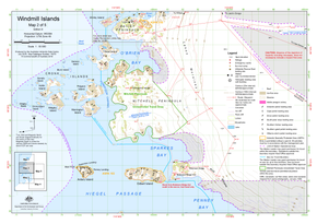
 Map of the Middle Windmill Islands with the Bailey Peninsula (above) |
||
The Bailey Peninsula is a rocky peninsula on the Budd Coast of the East Antarctic Wilke country . It separates Newcomb Bay from O'Brien Bay on the east flank of the Windmill Islands .
It was first mapped using aerial photographs taken by the United States Navy in February 1947 during Operation Highjump . At that time it was mistaken for an island connected to the continental ice on the Budd coast by a steep snow ramp . Their real nature identified the crew on Wilkes Station in 1957. The Advisory Committee on Antarctic Names named them after Claude Fenn Bailey (1910-2003), captain of the destroyer USS Henderson in Operation Highjump.
Australia has been operating Casey Station on the Bailey Peninsula since the 1960s .
Web links
- Bailey Peninsula in the Geographic Names Information System of the United States Geological Survey (English)
- Bailey Peninsula on geographic.org (English)
- Map of the Windmill Islands and the surrounding area (PDF, March 2009) at the Australian Antarctic Data Center (description)
