Balfour (Mpumalanga)
| Balfour | ||
|---|---|---|
|
|
||
| Coordinates | 26 ° 39 '38 " S , 28 ° 35' 19" E | |
| Basic data | ||
| Country | South Africa | |
| Mpumalanga | ||
| District | Gert Sibande | |
| ISO 3166-2 | ZA-MP | |
| local community | Dipaleseng | |
| height | 1621 m | |
| surface | 12.1 km² | |
| Residents | 3201 (2011) | |
| density | 264.5 Ew. / km² | |
| founding | 1897 | |
|
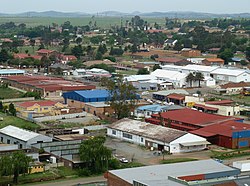
Aerial view of Balfour
|
||
Balfour is a city in the South African province of Mpumalanga . It is the seat of the municipality of Dipaleseng in the Gert Sibande district .
geography
In 2011 Balfour had 3201 inhabitants. To the east of Balfour is the Siyathemba township with 22,768 inhabitants.
history
Balfour was built in 1897 on the site of farms Vlakfontein 101 and 108 . At first the place was called Mc Hattiesburg after the farm owner. In 1905 it was named after the British Prime Minister Arthur Balfour , who gave a speech in the town at the time.
Economy and Transport
Mainly maize is grown around Balfour. There are coal mines near the city .
Balfour North Station is the separation station for the Johannesburg - Durban and Balfour North - Bethlehem lines . Balfour is located at the intersection of two trunk roads: the R23 connects Heidelberg in the west with Standerton in the east, while the R51 runs from Nigel in the north to Villiers in the southwest. The Rietbult Airfield is located north of Siyathemba.
Others
- Another South African place called Balfour is in the Eastern Cape Province .
Web links
- Balfour at sa-venues.com (English)
Individual evidence
- ↑ 2011 Census, Balfour , accessed November 14, 2016
- ↑ 2011 Census, Siyathemba , accessed November 15, 2016
- ↑ a b c Balfour at sa-venues.com (English), accessed on November 15, 2016

