
Bangli (administrative district)
| Kabupaten Bangli
|
||
|---|---|---|
 |
||
| Symbols | ||
|
||
|
Motto "Bhukti Mukti Bhakti" , for example: fun, freedom, eternal love ' |
||
| Basic data | ||
| Country | Indonesia | |
| Capital | Bangli | |
| surface | 520.8 km² | |
| Residents | 213,808 (2008) | |
| density | 411 inhabitants per km² | |
| founding | 1949 | |
| ISO 3166-2 | ID-BA | |
| Website | www.banglikab.go.id (Indonesian) | |
| politics | ||
| Bupati | I Made Gianyar, SH, M.Hum. | |
 |
||

Coordinates: 8 ° 20 ′ S , 115 ° 9 ′ E
Bangli is a government district ( Kabupaten ) on the island of Bali , Indonesia . It has an area of 520.81 km² and 197,210 inhabitants (2004). Its seat is the city of the same name Bangli ( ⊙ ) with 43,859 inhabitants (2005).
geography
Bangli is the only district without access to the sea. It borders (clockwise from the north) with Buleleng , Karangasem , Klungkung , Gianyar and Badung .
Bangli is essentially very mountainous. Here is the Batur with the crater lake of the same name . The mother temple of all Subaks Pura Ulun Danu Batur has stood on the edge of the caldera in Batur near Kintamani since the volcano erupted in 1926 .
History and administration
By 1907, Bangli was one of the nine kingdoms of Bali that existed at the time. The capital has a famous 11th century Hindu temple, the Pura Kehen .
Because of its relatively sparse population, the 56 villages ( Desa ) are grouped into only four districts ( Kecamatan ):
gallery

View into the caldera of the Batur
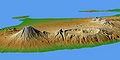
Agung left and Batur with caldera right

Entrance Pura Ulun Danu Batur
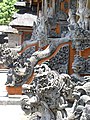
classic stone carving in the Pura Ulun Danu Batur


