
Kintamani
Coordinates: 8 ° 14 ′ S , 115 ° 19 ′ E
Kintamani is a village in the north of the Indonesian island of Bali in the Bangli administrative district .
location
The elongated street village is located at an altitude of 1470 meters in the northern mountains of the island on the main road from Bangli in the south to Singaraja on the north coast. The road running on the western edge of the outer two calderas offers views of the volcanic landscape of the 1,717 meter high Gunung Batur south of the village , the summit of which is about six kilometers to the east. A winding side road that leads to the foot of the mountain branches off eight kilometers southeast of Kintamani in Penelokan (1450 meters) and leads down to the bottom of the caldera, 120 to 300 meters below. The ascent and descent on foot directly from Kintamani to the summit of Gunung Batur takes about six hours. The street settlement of Batur lies between the two places and has practically grown together with Kintamani.
The road from Kintamani in a northerly direction continues to climb to Penulisan, where the Pura Tegeh Koripan , the highest temple in Bali, is located at 1745 meters .
The sky, which is often overcast at high altitudes, brings abundant rainfall. The fertile volcanic soils are particularly used for growing Arabica coffee .
place
The place name Kintamani is the modern spelling of Cintamani , consisting of cinta , Indonesian “love” and the Sanskrit word maṇi , “jewel”.
Every three days there is a lively market in the morning in Kintamani, where fruits and vegetables from the region are offered, otherwise the three places mentioned benefit greatly from tourism through numerous sales offers. There are several places to stay.
History and culture
The place has been known since the 9th century and belonged to the oldest kingdom in Bali. In villages in the area such as Tenganan , traditions of the mountain people have been preserved, which are known as Bali Aga from the settlers on the coast. Characteristics of the ancient culture are simpler temples, community-owned village land, the absence of the caste system typical of Balinese Hinduism, and a general lack of social hierarchy. The population around Kintamani was therefore often described as backward in ethnological descriptions of the 20th century. In contrast, the large number of inscriptions found mainly in this region show that the rulers of the early kingdoms were clearly influenced by the Hindu culture from Java . A cultural stagnation is only likely to have set in in the 14th century.

On the edge of Kintamani in the village of Batur stands Pura Ulun Danu Batur . The complex, dedicated to the water goddess Dewi Danu, is the second most important temple for the Balinese after Pura Besakih . The sanctuary, which dates back to the 11th century in the historical parts, and the village of Batur were originally located below in the caldera, at the foot of the volcano. The fact that 65,000 houses and 2,500 temples were destroyed in a devastating eruption of the Batur in 1917, but Ulun Dana Batur remained intact, was taken by the residents as a good omen and rebuilt the village on the same spot. In another outbreak in 1926, however, the buried lava the entire system, only the shrine of the goddess of water, a elfdachiger Meru was spared. The villagers took the shrine to the highest and oldest rim of the caldera and rebuilt the village and sanctuary, which has now grown to well over two hundred shrines, stone thrones for gods (“Padmasana”) and pavilions (“Bale”). The new temple complex made of black lava is grouped around the holiest shrine of the sea and river goddess Dewi Dana and comprises two building complexes with a total of nine individual temples . To the west, four shrines are arranged in a row, which are dedicated to the wives of King Anak Wungsu. The five shrines in the east represent King Udayana, King Marakata, King Wungsu, Gunapriya Dharma Patni and Queen Udayana. The innermost and largest centerpiece is Pura Penataran Ulun Danu Batur with three zones (“Tri Mandala”): The first, Jaba Sisi, symbolizes the world beneath humans (plants and animals). The second, Jaba Tengah, represents the realm of men, while in the innermost and holy of holies, Jeroan, the eleven-tier Meru stand for Dewi Dana and three nine-tier shrines. These are dedicated to the god of Gunung Agung , the god of Gunung Batur and Ida Batara Dalem Waturenggong, the elevated king of the Gelgel dynasty , who ruled from 1460 to 1550. The rituals and prayers held in the temple undoubtedly serve the prosperity of agriculture and commerce.
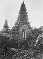
Lava in front of a gate of the Batur temple
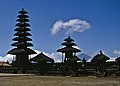
Pura Ulun Danu Batur, Gunung Agung in the background

11 Tumpang shrine for the water goddess


literature
- Samuel Wälty: Kintamani. Village, country and rituals. Development and institutional change in a mountain region in Bali. (Culture, Society, Environment - Writings on South Asian and Southeast Asian Studies, Volume 1). Lit-Verlag, Münster 1997, ISBN 3-8258-32643
- Heimo Rau: Indonesia . Kohlhammer Verlag , Stuttgart 1982, pp. 229-230, ISBN 3-17-007088-6 .
- Ernst Sagemüller, I Gde Semadi Astra: The Temple of Bali . Talisman Indonesia, Jakarta 1999, pp. 99-103, ISBN 979-15199-0-0 .
Web links
Individual evidence
- ↑ NL Sutjiati Beratha: Old Balinese Inscriptions: The Tradition of Studies. ( Page no longer available , search in web archives ) Info: The link was automatically marked as defective. Please check the link according to the instructions and then remove this notice. (PDF; 166 kB) Institut Seni Indonesia, Denpasar
- ↑ Freek L. Bakker: Bookreview Samuel Wälty In: Bijdragen tot de Taal-, Land- en Volkenkunde 154–4, Leiden 1998, pp. 640f