
Bardhaman
| Bardhaman | |||
|---|---|---|---|
|
|||
| State : |
|
||
| State : | West Bengal | ||
| District : | Bardhaman | ||
| Sub-district : | Bardhaman Sadar North | ||
| Location : | 23 ° 14 ' N , 87 ° 51' E | ||
| Height : | 35 m | ||
| Residents : | 314,265 (2011) | ||
 |
|||

Bardhaman (also Barddhaman ; Bengali : বর্ধমান , Bardhamān ; formerly English Burdwan ) is a city in the Indian state of West Bengal . It has about 330,000 inhabitants and is the administrative seat of the district of Bardhaman .
Bardhaman is located on the Damodar River about 100 km northwest of Kolkata on the Grand Trunk Road ( NH 2 ) and is connected to the Eastern Railway network.
The name of the city goes back to the 6th century BC. When the Jain Mahavira , whose real name was Vardhamana ( Sanskrit version of the Bengali Bardhaman ), stayed in the area and the place is said to have been renamed after him in honor.
Archaeological research justifies the assumption that the area was already between 4000 and 2000 BC. Been settled. Bardhaman was occupied by the Mughals , Pathan and the Kingdom of Maratha . Since 1657 the place was the seat of the local Zamindare (large landowners and tax collectors). Their loyalty to the English, especially during the Santal uprising (1855–56) and the great uprising of 1857, ensured them the continuation of their rule.
Bardhaman is culturally diverse; There are architectural evidence of Buddhist, Muslim and Hindu influence, the latter bearing symbols of the Sakta and Vaishnava . The grave of the Sufi Pir Baharam is also there. In addition to the Sarvamangala shrine, there are numerous other temples and shivalingams . Sights include the palaces and gardens of the Zamindari ( Golapbag ). Bardhaman has been a university town since 1960. It houses a planetarium named after Meghnad Saha .
photos
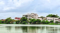
The Burdwan Medical College

Entrance to the University of Burdwan Administrative Complex

University of Burdwan south gate

Meghnad Saha Planetarium in Bardhaman
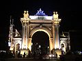
Curzon Gate

Sarbamangala temple


