
Bardhaman (District)
| Bardhaman District | |
|---|---|

|
|
| State | West Bengal |
| Division : | Bardhaman |
| Administrative headquarters : | Bardhaman |
| Area : | 7,024 km² |
| Residents : | 7,717,563 (2011 census) |
| Population density : | 1099 people / km² people / km² |
Bardhaman (also Barddhaman ; Bengali : বর্ধমান , Bardhamān ) was a district in the Indian state of West Bengal . As of April 7, 2017, it was divided into the districts of Pashchim Bardhaman and Purba Bardhaman . The seat of the district administration was the city of Bardhaman .
geography
The district of Bardhaman extended over an area of 7024 km² and had a population of 7,717,563 inhabitants (2011 census). Ten years earlier there were 6,895,514 inhabitants (2001 census). It bordered the West Bengal districts of Birbhum , Murshidabad , Nadia , Hugli , Bankura and Purulia as well as the state of Jharkhand . Bardhaman consisted of the six subdivisions Asansol , Bardhaman Sadar North , Bardhaman Sadar South , Durgapur , Kalna and Katwa .
The east of the district was part of the Ganges plain , the mouth of which Bhagirathi also formed the border with the neighboring district of Nadia. The west was shaped by the Damodar River , which was the border to the south with the Bankura district. The river Ajay formed the northern border to the Birbhum district .
economy
Bardhaman was one of the economically advanced areas of West Bengal. The east with its fertile alluvial soil, especially the Bhagirathi, was a productive region of agriculture with predominantly rice cultivation. The west was rich in mineral resources such as coal and ore. Coal mining was carried out here at Raniganj since the beginning of the 19th century . The iron, steel and construction industries had settled on the Damodar River. There were power stations in Durgapur and Dishergarh .
Bardhaman had a comparatively good infrastructure thanks to the National Highway 2 ( Grand Trunk Road ) and its location on the Delhi-Kolkata railway line.
photos
- temple
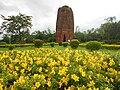
Deulia , Sat Deul Temple
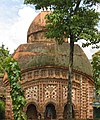
Kalna , Rameswar Temple
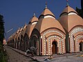
Bardhaman , 108 Shiva Temple

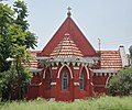
Bardhaman, Sarbamangala Temple

_in_Deulia_2.jpg)


- Other buildings
Bardhaman Church
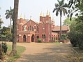
Asansol, Sacred Heart Church

Burdwan Palace

Burdwan Meghnad Saha Planetarium
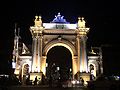
Curzon Gate


Web links
- Bardhaman District. In: The Imperial Gazetteer of India. Volume 9: Bomjur to Central India. New edition. Clarendon Press, Oxford 1908, p. 91.