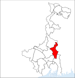
Nadia (District)
| Nadia District | |
|---|---|

|
|
| State | West Bengal |
| Division : | Presidency |
| Administrative headquarters : | Krishnanagar |
| Area : | 3927 km² |
| Residents : | 5,167,600 (2011 census) |
| Population density : | 1316 inhabitants / km² |
| Website : | nadia.nic.in |
Nadia ( Bengali : নদীয়া জেলা , Nadīẏā jelā ) is a district in the Indian state of West Bengal . It extends over an area of 3927 km² and had about 4.604 million inhabitants (2001 census) and 5.167 million inhabitants (2011 census). The district capital is Krishnanagar .
Nadia borders the West Bengal districts of Murshidabad in the north, Bardhaman and Hugli in the west, and Uttar 24 Pargana in the south. In the east is the border with Bangladesh .
Politically, Nadia is divided into the four subdivisions Ranaghat , Krishnanagar, Kalyani and Tehatta . These are divided into a total of 13 taluks .
Some of the most famous locations in Nadia include Nabadwip and the ISKCON headquarters Mayapur , as well as the site of Palashi , where the historic Battle of Plassey took place. In 1859 the village of Govindpur was the starting point for the indigo riots .
The district is dominated by agriculture. Rail and road connections from Kolkata to Bangladesh run through the Nadia district.
Web links
- official website of the Nadia district
- historical places
- Profile of the district on the West Bengal State website
- The Nadia district at mapsofindia.com
