
Purulia (district)
| Purulia District পুরুলিয়া জেলা |
|
|---|---|

|
|
| State | West Bengal |
| Division : | Bardhaman |
| Administrative headquarters : | Purulia |
| Area : | 6,259 km² |
| Residents : | 2,930,515 (2011 census) |
| Website : | Purulia district |
The district of Purulia or Puruliya ( Bengali : পুরুলিয়া জেলা) is part of the Indian state of West Bengal . The capital is the city of the same name Purulia .
geography
The by Kangsabati -carrying -River and other small rivers district Purulia bordered to the south, west and northwest of the state of Jharkhand , in the northeast on the district Bardhaman and the east and southeast of the districts Bankura and Paschim Medinipur district . The average altitude is around 250 m above sea level. d. M .; however, the rocky chain of hills of the Ayodhya Hills rises up to over 650 m .; the climate is mostly humid and rainy , especially in the monsoon months from June to October.
population
Official population statistics have only been kept and published since 1991.
| year | 1991 | 2001 | 2011 |
| Residents | 2,224,577 | 2,536,516 | 2,930,515 |
Hindus predominate mainly in rural villages (around 81% of the total population); in the cities, the proportion of Muslims (only around 8% of the total population) is also significant. As is usual with censuses in northern India, the male population exceeds the female share by around 5%. About 87.5% of the people live in rural villages and only about 12.5% live in cities.
economy
The district is still largely agriculturally oriented; However, due to the relative altitude, the district is drier and therefore less productive than the rest of West Bengal. However, there is an economically important silk processing company as well as several cement works . The hills of the district attract day-trippers from the otherwise flat south of West Bengal, who also stock up on souvenirs made here (especially lacquer work ).
history
.jpg)
The fertile alluvial land in the Ganges Delta prompted people to settle down early on, but the oldest evidence of human existence can be found in the higher areas of West Bengal. Isolated sources have existed since the Middle Ages, but even after the arrival of Islam in the 13th and 14th centuries, the comparatively sparsely populated and not very fertile landscape remained largely outside the sphere of interest of the conquerors - there are some older Hindu or Jain temples , but no historical mosques . In 1576, Bengal came under the control of the Mughal Empire , whose influence was successively replaced by the Marathas and later by the British in the 18th century .
Attractions
The main attractions of the district are the Deul temples of Banda, Pakbirra and Deulghata; these all date from the Middle Ages and early modern times and are largely influenced by Odisha's architecture. The former Fort Garh Panchakot is located in the far north of the district; there are several Bengali temples from the 17th and 18th centuries.

Banda, Deul Temple

Pakbirra, Jain Temple
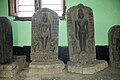
Pakbirra, Votive Temple and Jain Sculptures

Garh Panchakot , temple complex

Garh Panchakot, Jor Bangla Temple


Web links
- Purulia district - Tourism (English)
- Purulia district - Tourism (English)
- Purulia district - Temple (English)
Individual evidence
- ^ Purulia district - map + information
- ^ Purulia district map with elevation information
- ↑ Purulia district - climate tables
- ^ Purulia District - Census 1991 to 2011
- ^ Purulia District - Census 2011
- ^ Purulia District - Economy
- ^ Purulia District History
- ↑ Purulia District - Culture etc.

Alipurduar | Bankura | Birbhum | Dakshin 24 Pargana | Dakshin Dinajpur | Darjeeling | Haora | Hugli | Jalpaiguri | Jhargram | Kalimpong | Chef Bihar | Calcutta | Malda | Murshidabad | Nadia | Pashchim Bardhaman | Pashchim Medinipur | Purba Bardhaman | Purba Medinipur | Purulia | Uttar 24 Pargana | Uttar Dinajpur