
Birbhum
| Birbhum District বীরভূম জেলা |
|
|---|---|

|
|
| State | West Bengal |
| Division : | Bardhaman |
| Administrative headquarters : | Suri |
| Area : | 4,545 km² |
| Residents : | 3,502,404 (2011 census) |
| Website : | Birbhum District |

The Birbhum district ( Bengali বীরভূম জেলা ) is part of the Indian state of West Bengal . The capital is the city of Suri ; the district has a high proportion of tribal population.
geography
The Birbhum district, through which the Mayurakshi River and some other rivers flow, is bounded in the south by the Ajay River. It borders in the east on the West Bengal district of Murshidabad , in the southeast and south on the district of Bardhaman and in the west on the state of Jharkhand . The average altitude is around 80 m above sea level. d. M .; however, some of the hills of the Chota-Nagpur plateau, which forms the western border of the district, protrude up to 250 m; The climate in the west is rather hot and dry, in the east, on the other hand, it is mostly humid and particularly rainy in the months from April to October because of the monsoons .
population
Official population statistics have only been kept and published since 1991.
| year | 1991 | 2001 | 2011 |
| Residents | 2,555,664 | 3,015,422 | 3,502,404 |
Hindus (approx. 62%) and Muslims (approx. 37%) predominate mainly in the rural villages; in the cities Christians , Buddhists , Jains and Sikhs form small marginalized groups. As is usual with censuses in northern India, the male population exceeds the female share by around 5%. Approx. 87% of the people live in rural villages and only about 13% live in cities. In addition to numerous tribal dialects, Bengali and Hindi are spoken .
economy
The district is still largely agriculturally oriented; however, in the second half of the 20th century, deforestation created problems with soil erosion. The main crops are rice , wheat , oilseeds and sugar cane.
history
According to legend, already are Buddha and the last Jain - Tirthankara Mahavira in the 5th century. Wandered through the area whose old name was Vajjabhumi . The region ( Rarh ), which is largely inhabited by tribes , belonged to the Maurya in antiquity - and later to the Gupta empire , and in the Middle Ages to the rulership of the Pala and Sena . Islam arrived in the early 13th century , but the rather barren region remained outside of its economic, political and religious interests. The name Birbhum probably came about under the British .
Attractions

The main attraction of the district is Shantiniketan, which was brought back to life by Rabindranath Tagore in 1901 . Old Bengali temples stand on the Ajay River in the south of the district ( Nanoor , Jaydev Kenduli and Surul ).

Bengali temples in Nanoor
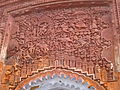
Terracotta relief in Surul
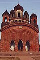
Radhabinode Temple in Jaydev Kenduli

Terracotta relief panels at the Radhabinode Temple


Web links
Individual evidence
- ^ Birbhum district - map + information
- ^ Birbhum district - map with elevation information
- ↑ Birbhum district (Siuri) - climate tables
- ↑ Birbhum district (Rajnagar) - climate tables
- ↑ Birbhum District - Census 1991 to 2011
- ↑ Birbhum District - Census 2011
- ↑ Birbhum District - Agriculture
- ↑ Birbhum District - Sights

Alipurduar | Bankura | Birbhum | Dakshin 24 Pargana | Dakshin Dinajpur | Darjeeling | Haora | Hugli | Jalpaiguri | Jhargram | Kalimpong | Chef Bihar | Calcutta | Malda | Murshidabad | Nadia | Pashchim Bardhaman | Pashchim Medinipur | Purba Bardhaman | Purba Medinipur | Purulia | Uttar 24 Pargana | Uttar Dinajpur