Barretos
| Barretos | ||
|---|---|---|
|
Coordinates: 20 ° 33 ′ S , 48 ° 34 ′ W Barretos on the map of Sao Paulo
|
||
| Basic data | ||
| Country | Brazil | |
| State | São Paulo | |
| City foundation | 1854 (Vila), 1885 (self-government) | |
| Residents | 112,101 (2010) | |
| City insignia | ||
| Detailed data | ||
| surface | 1563.611 km² | |
| Population density | 71.69 inhabitants / km 2 | |
| height | 530 m | |
| Time zone | UTC −3 | |
| City Presidency | Guilherme Ávila ( PSDB ) (2017-2020) | |
| Website | ||
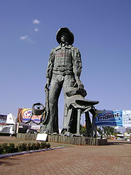
| Monument to the Shepherd (Peão), Barretos | ||
Barretos is a city in the Brazilian state of São Paulo . As of July 1, 2017, it had an estimated 120,638 inhabitants.
The city is located near the Rio Pardo at an altitude of 522 m . Barretos was also known as Amaral dos Barretos , Espírito Santo de Barreto and Espírito Santo dos Barretos at various times and was given parish status in 1885 .
Economy and Infrastructure
Every year in Barretos, the Festa do Peão de Barretos, the largest cattle market in the state and one of the world's largest rodeos, takes place. Citrus fruits and other useful plants are grown in the surrounding area . Important industries are the meat industry as well as the manufacture of shoes , furniture and agricultural implements . A railway line and a state highway, the SP-326 , connect Barretos with the capital São Paulo in the southeast, 421 kilometers away , the SP-425 with São José do Rio Preto in the west and Franca in the east. There is also an airfield .
Sons and daughters
- Eliza Branco (1912-2001), women and peace activist
Web links
- City Prefecture website , Prefeitura Municipal (Portuguese)
- City Council website , Câmara Municipal (Portuguese)
Individual evidence
- ^ Instituto Brasileiro de Geografia e Estatística (IBGE): Barretos: Panorama ; Retrieved December 14, 2017 (Portuguese).
- ↑ a b Barretos. In: Encyclopædia Britannica . Accessed December 14, 2017 .


