
Farmer's mountains

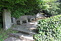
The farmer's mountain areas extend over the Linz cadastral municipalities and, to a lesser extent, Waldegg. They are located on the foothills of the Freinberg massif , the Bauernberg. They are limited by the streets Auf der Gugl, Roseggerstraße and Sandgasse as well as the park of the Chamber of Agriculture (formerly Hatschekvilla). Bernardisstraße, which is laid out as a park path, runs through the facilities in serpentines. Parts of the facility are under monument protection .
history
In 1885 the Linz Beautification Association bought the grounds on the Bauernberg. Until 1900 these served as a sand mining site. In 1910, the industrialist Ludwig Hatschek gave the city of Linz the grounds adjacent to his villa to create a park. In the years 1911 to 1915, city gardening director Josef Schweiger, who also designed the park of the Hatschekvilla, created today's Art Nouveau park. At the time, this was the largest construction project in the city of Linz. Ludwig Hatschek donated some works of art for the park, such as the mountain spirit created by Adolf Wagner von der Mühl , the Temple of Aphrodite and the Neptune Fountain.
In 1949, after damage in the Second World War, the park was redesigned in the style of the early 1950s under city gardening director Rudolf Hirschmann. The planting is designed in a varied variety of species; partly there are open lawns and old trees and bushes.
Works of art and structures in the park
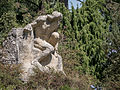
- Berggeist by Adolf Wagner von der Mühl (1912).
- Temple of Aphrodite , acquired from the Munich art trade in 1913. The bronze figure of Aphrodite by Wilhelm Wandschneider , erected in 1942, was a gift from Adolf Hitler to the city of Linz and was removed in 2008 by Mayor Franz Dobusch after this fact became known.
- Neptune fountain on Balzarekrondeau , acquired from the Munich art trade around 1913, new bronze sculpture by Walter Ritter (1955).
- Hermann Bahr Fountain by Fritz Fanta (1963).
- Ludwig Hatschek memorial niche by Karl Vornehm , medallion by Bernhard Schwarz (1928).
- Porter's house of the former Hatschekvilla, built by Mauriz Balzarek (1912).
Mountain spirit

Temple of Aphrodite without Aphrodite

Aphrodite before their removal in 2008
Hermann Bahr fountain
Balzarekrondeau

Fountain of Neptune
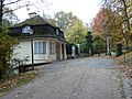
Porter's house of the former Hatschekvilla


.JPG)
literature
- Eva Berger : Historic Gardens of Austria. Gardens and parks from the Renaissance to around 1930. Volume 2. Böhlau, Vienna 2003.
- Géza Hajós , Matthias Cremer: Historical gardens in Austria. Forgotten total works of art. Böhlau, Vienna 1993.
Web links
- Bauernberg celebrates the 100th anniversary of the city of Linz.
- Bibliography on the mountain farm in the forum OoeGeschichte.at.
Individual evidence
- ^ Report ORF Upper Austria
- ↑ APHRODITE. An inventory. May 23, 2018 to February 24, 2019 Nordico Stadtmuseum Linz, 10 pages. Report on the whereabouts of the statue. Retrieved September 30, 2018.
Coordinates: 48 ° 17 ′ 39.7 ″ N , 14 ° 16 ′ 56.5 ″ E