
Steigerwald treetop path
| Steigerwald treetop path | ||
|---|---|---|
 Lookout tower on the Steigerwald treetop path |
||
| Data | ||
| place | Ebrach | |
| Client | Bavarian State Forests | |
| Construction year | 2015/2016 | |
| height | 26 m | |
| Coordinates | 49 ° 51 '3.9 " N , 10 ° 27' 31.4" E | |
|
||
| particularities | ||
Length :
|
||

The Steigerwald Treetop Path is a 1152 m long educational and treetop path between Ebrach and Breitbach in the Upper Franconian district of Bamberg , Bavaria .
geography
The treetop path is located in the southwestern area of the forest area Der Hohe Buchene Wald in the Ebracher Forst of the community-free area Ebracher Forst in the Steigerwald Nature Park at an altitude of about 410 m above sea level. NHN . It can be reached directly via federal highway 22, which leads south .
investment
The treetop path, which opened on March 19, 2016, is completely barrier-free over a length of 1152 m and at an average height of 26 m above ground. After about two thirds of the path you will reach a goblet-shaped observation tower that opens upwards and is mostly made of wood. The path on the outside of the tower enables barrier-free access to the circular walkway on the top level, from which one has a panoramic view of the wooded landscape of the Steigerwald.
The treetop path complements the “ Steigerwald Center - Experience Sustainability ” in the neighboring Lower Franconian town of Handthal as an adventure and educational facility for the Bavarian Forest Administration .
opening hours
The treetop path is open all year round, with opening times during the day depending on the seasons.
Picture gallery

Entrance building

Lookout tower view from above

Observation tower inside
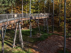
path
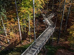
path

View from the observation tower

.jpeg)


Web links
Individual evidence
- ↑ Map services of the Federal Agency for Nature Conservation ( information ) - information according to contour lines
- ↑ Steigerwald treetop path
- ^ Bavarian State Forests: The Steigerwald Treetop Walk
- ↑ Steigerwald Center Handthal. Retrieved June 21, 2019 .
- ↑ Opening times of the Steigerwald treetop path