Bavški Grintavec
| Bavški Grintavec | ||
|---|---|---|
|
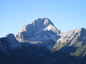
Bavški Grintavec, seen from the rear Trenta valley |
||
| height | 2347 m. i. J. | |
| location | Slovenia | |
| Mountains | Julian Alps | |
| Dominance | 3.6 km → Veli Pelc | |
| Coordinates | 46 ° 22 '8 " N , 13 ° 40' 13" E | |
|
|
||
| rock | limestone | |
The Bavški Grintavec (German also Flitscher Grintavec or Flitscher Grintoutz ) is a mountain in the Julian Alps in northwestern Slovenia ( 2347 m ).
Location and geography
The mountain is located in the center of the Triglav National Park . Its three rock ridges rise above the Bavšica valley ( scattered settlement belonging to Bovec ) on the northwest side, the rear Trenta valley with the Isonzo source on the north side and above Trenta on the southeast side. It is the highest peak of a mountain range running from northeast to southwest over the valley of the young Isonzo (Slov. Soča ).
Geologically dominate layers of the Upper Triassic ( Rhaetium and Norium ), as on the neighboring peaks as well as on the mountain range running to the north with the Jalovec as the highest peak . Formed 220-200 million years ago ( Dachstein limestone ).
Alpine pastures, mountain pines and coniferous forests stretch out below the rocky summit.
Ascent routes
All approaches extend over at least around 1,350 meters difference in altitude for 5–6 hours without refreshment stations and sometimes without water; they require appropriate perseverance. The ascent of the summit takes place at an altitude of approx. 300 meters via via ferrata provided with wire ropes and iron pins . There is usually still snow here until early summer. The mountain is particularly dangerous during a thunderstorm. The following routes have been developed:
- 5–6 hours ascent from the north (Trenta valley head above the hut near the Isonzo source, 960 m), through alpine pastures, mountain pines and scree, if the path is divided either over the Kanja saddle ( 2030 m , access to the via ferrata via north ridge), or on a more southerly route (stepped channel) to the summit.
- 6 hours ascent from the south (scattered settlement Soča , 491 m) on the south-eastern slope; the path ends on the more southern of the two via ferrata.
- 5–6 hours ascent from the west from the Bavšica valley; at the end, a connection with both via ferrata is possible here.
Web links
- Via ferrata in the google book search
- summitpost - Bavški Grintavec


