Beeston Regis
| Beeston Regis | ||
|---|---|---|
|
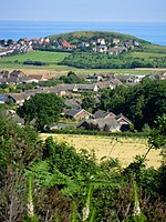
Beeston Regis ( Beeston Bump in the background ) |
||
| Coordinates | 52 ° 56 ' N , 1 ° 14' E | |
| OS National Grid | TG1642 | |
|
|
||
| Residents | 1091 (as of 2001) | |
| surface | 2.89 km² (1.12 mi² ) | |
| Population density | 377.5 inhabitants / km² | |
| administration | ||
| Post town | SHERINGHAM | |
| ZIP code section | NR26 | |
| prefix | 01263 | |
| Part of the country | England | |
| region | East of England | |
| Shire county | Norfolk | |
| District | North Norfolk | |
| Civil Parish | Beeston Regis | |
| British Parliament | North Norfolk | |
| Website: Official website | ||
Beeston Regis is a civil parish on the North Sea coast of Norfolk in England in the North Norfolk district . In 2001 it had 1,091 inhabitants. The place is 0.5 km from the A 149 , which connects Cromer with King's Lynn , and is just 5.2 km from Cromer to the west and Norwich to the north . London is a good 200 km south.
history
The place was formerly called Beeston-next-the-Sea . After Henry Bolingbroke, 2nd Duke of Lancaster, was crowned King Henry IV of England in 1399 , he was renamed Beeston Regis. The originally Latin suffix Regis [ ˈiːdʒɪs ] is the genitive singular of the Latin Rex "king" and means "the king".
Beeston Regis is mentioned in the Domesday Book . During World War II , Beeston Hill (also: Beeston Bump ), a 63 m high cliff directly on the North Sea coast, housed Beeston Hill Y Station , a radio eavesdropping station of the British secret service .
All Saints Parish Church
The tower of the All Saints Church is from the 14th century.
Web links
- Beeston Regis Parish Council , accessed May 15, 2017.
- Beeston Regis Norfolk Coast , accessed May 15, 2017.
Individual evidence
- ^ County A to Z Atlas, Street & Road maps Norfolk. ISBN 978-1-84348-614-5
- ↑ Beeston Regis , accessed May 15, 2017.

