Beinn Akhaladair
| Beinn Akhaladair | ||
|---|---|---|
|
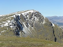
The Beinn Achaladair from, northwest Loch Tulla seen from |
||
| height | 1038 m ASL | |
| location | Highlands , Scotland | |
| Notch height | 225 m | |
| Coordinates | 56 ° 33 '6 " N , 4 ° 41' 42" W | |
|
|
||
The Beinn Achaladair (also Ben Achallader ) is a 1038 meter high mountain in Scotland . Its Gaelic name roughly means mountain at the field of hard water . The mountain is part of a group of four east of Bridge of Orchy lying Munros between Loch Lyon and Rannoch Moor form a small mountain group.

Among the mountains in the Bridge of Orchy Hills , the Beinn Achaladair is furthest to the northwest, its steep northwest side looming over Rannoch Moor and Loch Tulla . The mountain can therefore be seen particularly well from the A82 , the main road between Glasgow and Fort William that passes Loch Tulla, and is a landmark that can be recognized from afar . The steep, largely grassy slopes lead to a rocky summit ridge that roughly overhangs two kilometers in north-south direction. In the south, the ridge ends in the 1002 m high secondary summit of the South Top . North of the highest point, the ridge gradually tapers off towards the northeast, here the ridge joins with the transition to the neighboring Beinn a 'Chreachain . The West Highland Line runs at the foot of the mountain . Below in the north lies the Black Wood of Rannoch, a remnant of the pine forest that used to cover large parts of Scotland . To the east, the Beinn Achaladair has more gentle grass slopes. Here the Coire nan Clach opens up , which has various small mountain lakes below the summit. These drain via the adjoining Gleann Cailliche into Loch Lyon to the east . In the southwest of the mountain, the Corrie Achaladair , located between the Beinn Achaladair and the neighboring Beinn an Dòthaidh , opens to the north.
The Beinn Achaladair can be climbed on several routes. From the north, an approach leads from the Achaladair Farm and the ruins of Achallader Castle , slightly off the A82 north of Bridge of Orchy, to the south through the Corrie Achaladair to the saddle between Beinn Achaladair and Beinn an Dothaid, from there over the summit ridge north again to the highest point. There is also a transition to Beinn a 'Chreachain via the mountain ridge that connects the two Munros , so Munro excavators like to climb both peaks together.
Individual evidence
- ↑ Munro tables of the Scottish Mountaineering Club (SMC)
- ↑ Tour description to Beinn Achaladair on walkhighlands.co.uk
Web links
- The Beinn Achaladair on walkhighlands.co.uk (English)
- The Beinn Achaladair on munromagic.com (English)

