Belo Oriente
| Belo Oriente | ||
|---|---|---|
|
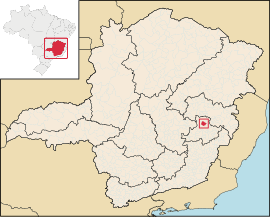
Coordinates: 19 ° 13 ′ S , 42 ° 29 ′ W Belo Oriente on the map of Minas Gerais
|
||
| Basic data | ||
| Country | Brazil | |
| State | Minas Gerais | |
| City foundation | December 30, 1942 | |
| Residents | 23,397 (2010) | |
| Detailed data | ||
| surface | 336,012 | |
| Population density | 69.63 inhabitants / km 2 | |
| height | 350 m | |
| Time zone | UTC −3 | |
| City Presidency | Humberto Lopes de Assis | |
| Location of Belo Oriente in the state of Minas Gerais | ||
Belo Oriente , officially Portuguese Município de Belo Oriente , is a city in Minas Gerais , Brazil .
From 1989 to 2017 it was in the Ipatinga microregion and the Vale do Rio Doce mesoregion and borders the communities of Açucena , Mesquita , Santana do Paraíso , Ipaba , Bugre , Iapu and Naque .
Individual evidence
- ↑ Instituto Brasileiro de Geografia e Estatística (IBGE): Populacional 2010 ( Memento of January 24, 2011 in the Internet Archive ) , visited on December 28, 2010.

