
Besso (mountain)
| Besso | ||
|---|---|---|
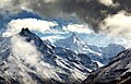
 Besso (right) and Zinalrothorn (left) |
||
| height | 3668 m above sea level M. | |
| location | Canton of Valais , Switzerland | |
| Mountains | Valais Alps , Weisshorn Group | |
| Dominance | 1.6 km → Zinalrothorn | |
| Notch height | 149 m ↓ unnamed notch | |
| Coordinates | 617 028 / 102924 | |
|
||
| First ascent | 1862 by JB Epinay and J. Vianin | |

The Besso is a 3668 m above sea level. M. high mountain in the Val d'Anniviers in the canton of Valais , Switzerland . The name Besso means twins in the patois (French dialect) of the Val d'Anniviers and refers to the two peaks of the mountain. It towers over the resort of Zinal and lies northwest of the Zinalrothorn .
The first ascent was probably made in 1862 by the two mountain guides JB Epinay and J. Vianin.
The easiest route on the Besso is known as the “Chemin des Dames” (ladies route). The classic route starts from the Cabane du Mountet and leads over the southwest ridge ( PD + ). According to Collomb, this route was first set out in 1906 by the British writer and alpinist Robert Lock Graham Irving .
Besso (left), with the Ober Gabelhorn (right)

The Besso up close.

The Besso with its twin peaks.

The Val de Zinal with Besso (left).


Web links
Individual evidence
- ^ Collomb, Robin G., Pennine Alps Central , Alpine Club, London 1975, p. 75.