
Bet Guvrin Marissa National Park
| Caves of Marissa and Bet Guvrin in the lowlands of Judea as a microcosm of the "land of the caves" | |
|---|---|
|
UNESCO world heritage |
|

|
|
| Bell cave |
|
| National territory: |
|
| Type: | Culture |
| Criteria : | v |
| Surface: | 259 ha |
| Reference No .: | 1370 |
| UNESCO region : | Europe and North America |
| History of enrollment | |
| Enrollment: | 2014 (session 38) |
The Bet Guvrin Marissa National Park (Hebrew: גן לאומי בית גוברין) is an Israeli national park in the southern district of Israel . It covers an area of around five square kilometers. Within this area lie the remains of the two ancient cities of Eleutheropolis and Marissa . The national park is known for its numerous caves that can be entered by visitors. On June 22, 2014, the caves were added to the UNESCO World Heritage List .
geography
The national park is located about 30 kilometers east of the city of Ashkelon in the Judean lowlands, not far from the border with the West Bank. The grounds of the national park are embedded in a gently rolling limestone landscape that reaches heights of up to 400 meters above sea level. The national park is divided by National Road 35. In the southern part is the Tel Maresha (Marissa) and its caves, in the north are the remains of settlements from the Roman-Byzantine period and the Crusader period.
Archaeological exploration of the area
In the years 1898–1900 extensive excavations were carried out by the two archaeologists Frederick J. Bliss and RAS Macalister in Marissa on behalf of the Palestine Exploration Fund . From 1902, the archaeologists Hermann Thiersch and John Punnett Peters examined two Sidonian grave caves in the southeast of Tell Marissa. In the 1960s and 1970s, further investigations and a. carried out by the Israeli geographer Yehoshua Ben Arieh. Under Amos Kloner, further large-scale excavations began in 1989 on behalf of the Israel Antiquities Authority, which were completed in 2000. Smaller excavations followed, which will continue in 2013.
Sights in the national park
- At the foot of Tell Marissa is the so-called Columbarium ( Latin dovecote ). The underground facility in the form of a double cross has more than 2000 wall niches in which pigeons were bred for their meat and valuable guano . For a long time it was assumed that this is a grave cave from pre-Christian times, in which, similar to Roman necropolis , burial niches are set. Researchers have now moved away from this notion.
- Furthermore, the so-called bathing cave with tubs hewn out of the rock is located on the site .
- Popular because of their magnificent tomb paintings, which u. a. The Sidonian burial caves include numerous animal and mythological representations . They date from the 3rd and 2nd centuries BC, when the residents of Marissa used to bury their dead in burial niches. The paintings were restored in 1993.
- Immediately north of National Road 35 are some remains of the ancient Eleuteropolis , including a Roman amphitheater that was used as a marketplace in Byzantine times , remains of a crusader fortress and parts of a Roman bathhouse.
- In the area of the former city of Eleuteropolis, you can also visit the bell caves , which owe their name to their bell-like shape. They come from the Byzantine and early Muslim times and served as underground quarries. The bell caves have numerous openings in the ceilings through which daylight penetrates the cave system.
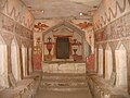
Paintings in the Sidon tombs

One of the bell caves

Amphitheater in Eleutheropolis

Settlement remains in Eleutheropolis

Typical vegetation and limestone cliffs in the national park

Columbarium


.JPG)

Web links
- Entry on the UNESCO World Heritage Center website ( English and French ).
- National park administration, information about Bet Guvrin (English)
Individual evidence
- ↑ Newsletter of the Embassy of the State of Israel from June 26, 2014
- ↑ a b c d Information flyer "Bet Guvrin-Maresha National Park" of the Israel Nature And Parks Authority, written by Amos Kloner.
- ↑ Jerome Murphy-O'Connor: The Holy Land: An Oxford Archaeological Guide . Oxford University Press, 2008, p. 214
- ↑ a b Michel Rauch: Baedeker Travel Guide - Israel, Palestine; Ostfildern 2010, page 191 ff.
- ↑ National Park Management , history and archeology , accessed on January 12, 2020.
Coordinates: 31 ° 36 ′ 1 ″ N , 34 ° 53 ′ 46 ″ E
Achziw National Park | Alexander River National Park | Ashkelon National Park | Awdat National Park | Bar'am | Bet Alpha | Bet Guvrin Marissa National Park | Bet She'an | Bet She'arim | Jehiam Castle National Park | Nimrod Castle 1 | Caesarea Maritima | Chorazin | Churschat Valley National Park | En Awdat National Park | En Gedi | En Hemed National Park | Eshkol National Park | Gamla National Park | Gan haSchloscha | Hamat Tiberias National Park | Har Carmel National Park | Harod Spring National Park | Herodium 1 | Hermon National Park (Banyas) 1 | Jarkon Afek National Park | Kochaw HaJarden National Park | Korazim National Park | Kursi National Park 1 | Mamshit National Park | Masada | Qumran 1 | Machtesch Ramon | Sharon National Park | Schivta National Park | Schomron National Park | Sde Boker, tomb of David Ben-Gurion | Tel Arad | Tell Beer Sheva National Park | Tel Dan | Tel Megiddo | Zippori

Heritage: Masada (2001) | Old City of Acre (2001) | White City of Tel Aviv (2003) | Biblical Hill of Settlements - Megiddo, Hazor and Beer Sheva (2005) | Incense Route - Desert Cities in the Negev (2005) | Holy Places of the Baha'i (2008) | Sites of human evolution in the Carmel Mountains (2012) | Marissa and Bet Guvrin Caves (2014) | Bet She'arim (2015)