
Mamshit

Mamshit (or Mamshit , Hebrew ממשית), also Mampsis or Mamphis ( ancient Greek Μαμφις ), Arabic كرنب, Kurnub , is an Israeli national park in the northern Negev . Mamshit is part of the UNESCO World Heritage Site Incense Route and Desert Cities in the Negev . In the 142 ha national park there are ruins of the city of Mamshit (4 ha) from the Nabatean , Roman and Byzantine times as well as the Wadi Mamschit outside the city and dams from ancient times.
Location on Weihrauchstrasse

Wadi Mamshit (downstream, to the east)

Wadi Mamshit (upstream, to the west) with dam


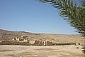
The Mamshit National Park is located about 7 km east of Dimona and 42 km southeast of Be'er Scheva directly on Wadi Mamschit. This is where ancient trade routes crossed, connecting Petra (capital of the Nabataeans), Eilat on the Red Sea , Gaza on the Mediterranean , the Dead Sea and Hebron in the Judean Mountains .
Mamshit is on one of the important branches of the Incense Route in the Negev . The Incense Route, about 2,400 km in length, is an ancient trade route from Oman and Yemen through Saudi Arabia and then the Negev Desert to the port of Gaza for the transport of goods by ship to ancient Greece and the Roman Empire . On the route from the 3rd century BC. Until the 4th century AD, spices such as frankincense and myrrh , in particular , were transported by caravans. The social and cultural exchange between the Orient and Occident ( Occident ) was also linked to trade .
history
Most of the buildings visible today as ruins were built in the Nabatean period (1st and 2nd centuries). The city wall with the city gate dates from the late Roman period (3rd and 4th centuries), the two churches and the bathhouse from the Byzantine period (up to the 7th century). A police station was built in the southeast of the historic site during the British Mandate in the 20th century (1936).
Nabataean city


Mamshit was founded by the Nabataeans in the middle of the 1st century AD (around the year 70). As a trading town with a caravanserai (in the northwest directly in front of the city wall), stables, residential and administrative buildings, it experienced a heyday in the Nabatean period (1st and 2nd centuries). It is estimated that there were around 1000 inhabitants at that time. As caravan traders, the Nabataeans also controlled the incense route. The extraordinary irrigation system of the Nabataeans, the so-called flash water agriculture, was of decisive importance for the supply of the caravans at the resting and trading places in the extremely arid climate of the Negev desert. The rain collecting area exceeded the agricultural area by more than 10 times. Mamschit is representative of this with the dams built by the Nabataeans in Wadi Mamschit, rainwater canals and cisterns. The public water reservoir in the northeast by the city wall was originally covered and was 10 by 18 m in size and 3 m deep. It also picked up rainwater from outside the city walls.

Nabatean column capital in the wealthy house

Stone arches in the wealthy house

Stables (with feeding troughs ) in the Nabatean residential area at the western church


The remains of a former three-storey watchtower, large-scale administration buildings and three living quarters with inner courtyards that have been preserved as ruins, stone arches supporting the ceiling, stairs to the upper floor, kitchen and toilet niches bear witness to the prosperity in Mamschit. The two-storey so-called wealthy house , which was once apparently particularly magnificent, reveals a reception hall, a kitchen, rooms for servants and a niche for a water jug in the inner courtyard on an area of 1000 m 2 . Some column capitals show typical Nabataean ornaments. Mamschit ran an architecture school and horse breeding (after the caravan trade no longer ensured sufficient economic income). A street known as a market dates from the Nabatean period with rooms on both sides of the street that were used for trade and living. As in the wealthy house , wealthy people must have lived in what is known as the Nabatu House to the east . Firstly, the size of the property (including a large yard with an attached stable for around 20 horses) of 1600 m 2 speaks for this . Second, stairs suggest that there must have been more floors. Thirdly, 10,800 silver coins from the years 75 to 200 were found under a staircase. The name Nabatu house goes back to the many Nabatean peculiarities, such as frescoes from Greek mythology.
Together with Schivta , Mamshit belonged to the Nabatean desert cities of the second generation, which were supposed to connect the older triangle of cities Awdat (Oboda) - Elusa - Nessana more closely. Under Trajan , the Nabataeans lost their relative independence in 106 and were incorporated into the Roman Empire as the Roman province of Arabia Petraea . Most of the city's buildings were built in the 2nd century. The Romans built military quarters in Mamshit. The Nabataean irrigation methods continued to be used.
Byzantine city


Christianity apparently spread relatively early among the Nabataeans. Apparently there was a Christian community in Mamshit as early as the 4th century, because two Byzantine churches of considerable size, the ruins of which can still be seen today, were built at the beginning of the 5th century. The chronological classification is supported by two finds in the floor mosaics of the two churches: In the Eastern Church there are two crosses in the floor mosaic that were no longer permitted after 427. The Eastern Roman Emperor Theodosius II had forbidden to put crosses on floors in 427 so that no one would step on the sign of redemption. In the western church a floor mosaic shows the inscription (Greek): "God, protect your servant Nilus, friend of Jesus, who founded this building. Preserve him and his household." St. Nilus , also known as the Nilus of Sinai , was initially a state official a. a. with Emperor Theodosius II and died as a monk on Mount Sinai in 430 . The two churches were built in the form of a basilica with main and side aisles , a central apse and two side apses. Finds indicate that the latter were used to venerate the relics of martyrs . In both churches, mosaic floors show ornaments as well as birds, including two peacocks . The Eastern Church, also known as the "Church of the Martyrs", was attached to a monastery . In the south aisle of the church is a recessed into the floor cross-shaped is the baptismal font , Piscina (lat. Piscina , "water tank") called, in which the candidate for baptism on the descend one side on steps and from which it after receiving the baptism of on opposite side emerges.
To the east of the western church is a typical Nabatean house with a cistern and stables, which can be reached through an inner courtyard. This house, built in the Nabatean style, was also used in Byzantine times, as shown by crosses on the lintel. To the north of the Nabatu house , right next to the water reservoir and connected to it by a canal, a bathhouse from the Byzantine era was built. This consists of a dressing room, a hot, a warm and an oven room for heating the system.
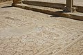
Floor mosaic with peacock pattern of the west church
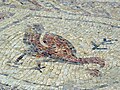
Floor mosaic of the west church
Mamshit city gate from the late Roman period


As part of the 900 m long city wall, the city gate dates from the late Roman period. The gate is shown on the Byzantine mosaic map of Madaba (Jordan) from the 6th century with two towers and a pediment and the ancient Greek place name ΜΑΜΨΙΣ . There was another gate in the western city wall in the direction of the dam in Wadi Mamschit. Until the Arab conquest in 636, the city was inhabited and the churches were in use. After that, Mamshit fell into disrepair.
Archaeological exploration
The first descriptions of the ruins are due to Ulrich Jasper Seetzen (1807), Edward Robinson (1838) and Edward Henry Palmer (1871). The archaeological excavations began in 1959 under the direction of Shimon Applebaum and Avraham Negev from the Hebrew University of Jerusalem and then in 1993/1994 by Talli Erickson-Gini. Mamschit was declared a national park in 1966 and made public by the Israel Nature and Parks Authority (INPA). In 2005, the Mamshit National Park, along with the desert cities of Avdat, Haluza and Shivta, was declared a World Heritage Site by UNESCO under the title Frankincense Route and Desert Cities in the Negev .
literature
- Avraham Negev: The Architecture of Mampsis. 2 vols. (= Qedem Monographs 26/27). Jerusalem 1988.
- Avraham Negev: Kurnub , in: The Oxford Encyclopedia of Archaeological Excavations in the Near East vol. 3, ed. By Eric M. Meyers. Oxford / New York 1997, 312-314.
- Tsvika Tsuk: Mamshit National Park. The Israel Nature and Parks Authority ( org.il [accessed May 31, 2018]).
Web links
- UNESCO: The Incense Route - Desert Cities in the Negev. (PDF, 45 MB)
- Cura Aquarum in Israel 2014. Report (PDF, 7.7 MB).
- R. Wenning: Mampsis. In: Religion Past and Present . doi : 10.1163 / 2405-8262_rgg4_SIM_13482
Coordinates: 31 ° 2 ′ N , 35 ° 4 ′ E
Achziw National Park | Alexander River National Park | Ashkelon National Park | Awdat National Park | Bar'am | Bet Alpha | Bet Guvrin Marissa National Park | Bet She'an | Bet She'arim | Jehiam Castle National Park | Nimrod Castle 1 | Caesarea Maritima | Chorazin | Churschat Valley National Park | En Awdat National Park | En Gedi | En Hemed National Park | Eshkol National Park | Gamla National Park | Gan haSchloscha | Hamat Tiberias National Park | Har Carmel National Park | Harod Spring National Park | Herodium 1 | Hermon National Park (Banyas) 1 | Jarkon Afek National Park | Kochaw HaJarden National Park | Korazim National Park | Kursi National Park 1 | Mamshit National Park | Masada | Qumran 1 | Machtesch Ramon | Sharon National Park | Schivta National Park | Schomron National Park | Sde Boker, tomb of David Ben-Gurion | Tel Arad | Tell Beer Sheva National Park | Tel Dan | Tel Megiddo | Zippori

Heritage: Masada (2001) | Old City of Acre (2001) | White City of Tel Aviv (2003) | Biblical Hill of Settlements - Megiddo, Hazor and Beer Sheva (2005) | Incense Route - Desert Cities in the Negev (2005) | Holy Places of the Baha'i (2008) | Sites of human evolution in the Carmel Mountains (2012) | Marissa and Bet Guvrin Caves (2014) | Bet She'arim (2015)

