
Schivta National Park

Schivta or Shivta (Hebrew: שבטה) is an Israeli national park in the Negev . The visitor mainly encounters ruins of a Byzantine city. Today's national park was declared a UNESCO World Heritage Site Incense Route - Desert Cities in the Negev by UNESCO in 2005, along with other cities of Nabatean origin in Israel .

Surname
The name Schivta is a modern ( neo-Hebrew ) replica of the Aramaic name of the settlement, which is not recorded in the sources, but can be deduced from the place name in Byzantine sources - Σουβαιτα Soubaita or Σοβατα Sobata - and the modern Arabic name es-Subeṭa . (Meaning: "stick, chopsticks.")
history


Nabataean city
Together with Ruchebe and Mamschit , Schivta belonged to the Nabatean desert cities of the second generation, which were supposed to connect the older city triangle Oboda (Awdat) - Elusa - Nessana more closely. Schivta was probably founded in the 1st century AD and experienced its first heyday around 150. The earliest Nabatean coins and inscriptions found in Shivta are from the beginning of the 2nd century. The Nabataeans had already farmed here, but at that time Schivta was primarily a stopover between Oboda and Nessana on the trade route to the Mediterranean. The developing shipping route from India to the Roman Empire led to competition for the caravan trade and thus to the decline of this branch of industry up to the 3rd century also for Schivta, so that agriculture grew in importance. To the north of the city are the remains of Nabatean settlements with an unusual but typical irrigation system for the Nabateans (including dams) as the basis for so-called flash water agriculture , which was of crucial importance for the supply of the inhabitants and caravans in the Negev desert.
Byzantine city
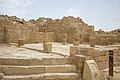
Shivta was settled again around 450 AD. The city of Shivta was not surrounded by a city wall. In Schivta, the purpose of a city wall was fulfilled by the outer walls of the houses built close together without windows or door openings on the outer edge of the city. In the area around the city, which had neither a well nor a spring, a remarkable irrigation system was built (cisterns, canals, terraces). Seasonal rains in winter were the primary basis of Shivta's water supply. It is assumed that in the 5th century the climatic conditions of Shivta were at least seasonally more humid and rainier. An aqueduct begins 2.5 km northeast of Schivta and leads to the southwest of the city - also along under the north church - to the inner-city water reservoir. In the southern center of the city you can see one of the two large contiguous polygonal water basins, which together had a volume of 2,000 m 3 and were publicly used. A wide street leads here from the western city gate (so called, although there was no city wall), on both sides of which there were residential quarters, some of which were two-story. Stables with stone feed troughs are evidence of former cattle husbandry - probably also for passing caravans. The residential quarters including the inner courtyards had a size of around 350 m 2 . According to a mapping of the settlement structure of Shivta from the 6th to 8th centuries carried out in 2009, 1,262 rooms and 141 courtyards were found, which belong to 117 building units, including 75 residential quarters and 29 business units. The city is divided into 27 blocks. The population during the Byzantine heyday in the 5th century is estimated at 2,000. In Roman-Byzantine times, a household consisted of 8 to 16 people.
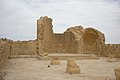
Immediately to the east of the water basin are the south church and a mosque. One after the other, the south church, the north church and finally (around 600 AD) the middle church were built. The three churches are three-nave columnar basilicas. In the anteroom of the south church there is a baptistery with a cross-shaped baptismal font , called piscina (from Latin: piscina = water container), into which the person to be baptized descends on one side and from which he emerges on the opposite side after receiving the baptism . According to an inscription on a lintel, the south church was built from 415 to 430. Another inscription says that in 640, after the Arab invasion, the floor was re-laid with stone slabs. To the north of this church, a mosque was built as a small neighbor in the 7th century - with two rows of three columns each. According to the grave inscriptions, many of the inhabitants were Arabs. The transition to the Arab period was peaceful and without any signs of destruction.
Approximately in the middle between the south and north church is the middle church and immediately next to it a town hall with a striking tower, the remains of which are still 6 m high. It is believed that the entire three-story tower of the house could have been 12 meters high. The tower homestead is known as the Governor's House . The house is interpreted as a residential building that also served official administrative functions. The tower-shaped entrance leads to the inner courtyard of the town hall . Here - as in many other parts of the city - a cistern can be seen. Presumably every house in the town of Shivta had a cistern, which was filled by precipitation, aqueduct and possibly the two central reservoirs. There are six cisterns in the three churches. The cistern in the northern churchyard is 9.7 m in diameter and has a volume of 162.5 m 3 .
Further north one arrives at a northern central square, which could have been the social and economic center of the city of Shivta. On the west side of the square is a house with stone benches. This house could have been the town house, a place for discussing communal issues. On the east side of the square is the artisan quarter, in which a large, well-preserved grape press testifies to the strong performance of local viticulture and a baking or pottery oven can also be seen. Archaeologists have also identified two taverns and a hostel for tourists in the square . To the north of the square is the north church. At the entrance to the north church there is an isosceles cross with the Christ monogram on a lintel . H. the Greek letters X and P can be seen in the upper part and the Greek letters Alpha and Omega in the lower part. At the ruins of the north church there are remains of a monastery complex.
The residents of Schivta were also settled border soldiers, monks and clerics, and pilgrims. In addition to agriculture, the inhabitants also made their living from pilgrimage tourism to St. Catherine's Monastery on Sinai. Agriculture gradually deteriorated, and with it the livelihood, so that more and more residents emigrated in the 8th and 9th centuries and the city was finally abandoned in the 9th century.
Archaeological exploration
The first description of the ruins is due to Edward Henry Palmer (1870); he mentioned the excellent state of preservation of the ancient site with walls over 7 meters high. Palmer also identified the three churches. In 1904, archaeologists from the École Biblique Schivta investigated and discovered a spolia on which there was a dedication to the Nabataean deity Dushara .
Charles Leonard Woolley and Thomas Edward Lawrence examined Schivta and the surrounding area as part of a 1914 survey; they noticed that wine had been grown here in Byzantine times (presses, field towers, cisterns). Theodor Wiegand was next on site in 1916 for the German-Turkish Monument Protection Command. He confirmed what Palmer and Wooley / Lawrence had noticed: the desert city had no defensive wall. Wiegand documented the church architecture and the construction of the houses, which he (incorrectly) considered to be one-story.
The large-scale excavation of Shivta in three campaigns led by Harris Dunscombe Colt (Colt Archaeological Expedition, 1933–1938) was unfortunately not only not published, the complete excavation documentation and the finds, including the architectural ornamentation, have been lost since the Palestinian uprising.
From 1958 to 1960 the archaeological site was cleared and the central church was uncovered under the direction of Michael Avi-Yonah on behalf of the national park authorities; however, there were changes in the building stock that were not documented.
In Shivta is the oldest depiction of the baptism of Jesus in the Holy Land that has been discovered to date, which was probably made before the 6th century. It shows a beardless Jesus with short, curly hair, an elongated face and large eyes; this type is very rare in the region.
gallery

South church
mosque
Medium church

Wine press

Baking or pottery oven


literature
- Othmar Keel , Max Küchler : Places and landscapes of the Bible: a manual and study travel guide , Volume 2: The south. Vandenhoeck & Ruprecht, Göttingen 1982, ISBN 3-525-50167-6 . Pp. 159-169.
- Birgit Borowski: Shivta (Subeita) . In: Israel . 4th edition. Karl Baedeker, Ostfildern 1991, ISBN 3-87504-507-6 , p. 351-352 .
- Constanze Röhl: Shivta, architecture and society of a Byzantine settlement in the Negev . Cologne (Diss.) 2010 ( online )
- Renate Rosenthal-Heginbottom: The churches of Sobota and the three -apse churches of the Middle East. Shivta (Subeita) . In: Göttinger Orientforschungen: Series, studies on late antique and early Christian art . tape 7 . Harrassowitz , Wiesbaden 1982, ISBN 3-447-02286-8 , pp. 281 .
Web links
- National Park Administration, Shivta National Park. The Israel Nature and Parks Authority(English, Hebrew, Arabic).
Coordinates: 30 ° 52 ′ 51 ″ N , 34 ° 37 ′ 51 ″ E
Individual evidence
- ↑ Constanze Röhl: Shivta. Architecture and society of a Byzantine settlement in the Negev. Introduction . Cologne (Diss.) 2010 .
- ↑ Constanze Röhl: Shivta . S. 15 .
- ↑ Constanze Röhl: Shivta . S. 16 .
- ↑ Archaeologists discover the oldest depiction of Jesus in the Holy Land. In: kathisch.de . November 15, 2018, accessed November 16, 2018 .
Achziw National Park | Alexander River National Park | Ashkelon National Park | Awdat National Park | Bar'am | Bet Alpha | Bet Guvrin Marissa National Park | Bet She'an | Bet She'arim | Jehiam Castle National Park | Nimrod Castle 1 | Caesarea Maritima | Chorazin | Churschat Valley National Park | En Awdat National Park | En Gedi | En Hemed National Park | Eshkol National Park | Gamla National Park | Gan haSchloscha | Hamat Tiberias National Park | Har Carmel National Park | Harod Spring National Park | Herodium 1 | Hermon National Park (Banyas) 1 | Jarkon Afek National Park | Kochaw HaJarden National Park | Korazim National Park | Kursi National Park 1 | Mamshit National Park | Masada | Qumran 1 | Machtesch Ramon | Sharon National Park | Schivta National Park | Schomron National Park | Sde Boker, tomb of David Ben-Gurion | Tel Arad | Tell Beer Sheva National Park | Tel Dan | Tel Megiddo | Zippori

