Biabuti
| Biabuti | ||
|---|---|---|
|
|
||
| Coordinates | 8 ° 54 ′ S , 125 ° 23 ′ E | |
| Basic data | ||
| Country | East Timor | |
| Ermera | ||
| Administrative office | Atsabe | |
| ISO 3166-2 | TL-ER | |
| Suco | Leimea Leten | |
| height | 1241 m | |
| Residents | 185 (2015) | |
|
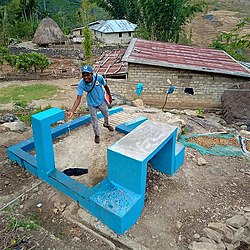
Water point in Biabuti
|
||
Biabuti ( Biaboti ) is a village and Aldeia des Sucos Leimea Leten ( Atsabe administrative office , Ermera municipality ). In 2015 the Aldeia had 185 members.
Biabuti is located south of the center of the Sucos Leimea Leten, north of the Magapu River, a tributary of the Lóis . Biabuti is located at an altitude of 1241 m .
Individual evidence
- ↑ Direcção-Geral de Estatística : Results of the 2015 census , accessed on November 23, 2016.

