
Biacou
| Biacou | |||
|---|---|---|---|
|
|||
| Coordinates | 8 ° 50 ′ S , 125 ° 3 ′ E | ||
 Biacou is on the coast of Nitibe Biacou is on the coast of Nitibe
|
|||
| Basic data | |||
| Country | East Timor | ||
| Bobonaro | |||
| Administrative office | Atabae | ||
| ISO 3166-2 | TL-BO | ||
| Suco | AIDS balets | ||
| height | 15 m | ||
 Biacou
|
|||

Biacou ( Biacau ) is an East Timorese village in Suco Aidabaleten ( Atabae administrative office , Bobonaro municipality ).
geography

Biacou is located on the coast of the Sawusee , on Lago Blacau . Mangroves cover the area between the lake and the sea. The northern coastal road, one of the most important traffic routes in the country, runs through the town and leads from the south of Biacous in part through the interior.
In Biacou there is a primary school ( Escola Primaria Biacou ). There is also a traditional holy house ( tetum Uma Lulik ) and an artificial Marian grotto (Gruta) . The Biacous Chapel is a simple, white, gabled building,
gallery
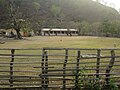
primary school
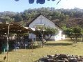
chapel
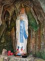
Mary's Grotto


Web links
Individual evidence
- ↑ http://websig.civil.ist.utl.pt/timorgis/Maps@[email protected] ( Memento from June 30, 2007 in the Internet Archive ) Timor-Leste GIS portal
- ↑ List of polling stations for the parliamentary elections in East Timor 2007 (PDF file; 118 kB)
The administrative borders within East Timor changed in 2015. This article must therefore be checked and updated if necessary. See New Administrative Boundaries .