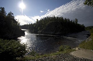
Big Sevogle River
| Big Sevogle River | ||
|
Square Fork at the confluence of the North Branch and South Branch Big Sevogle River |
||
| Data | ||
| location | New Brunswick ( Canada ) | |
| River system | Miramichi River | |
| Drain over | Northwest Miramichi River → Miramichi River → Atlantic Ocean | |
| Confluence of | North Branch and South Branch Big Sevogle River 47 ° 6 ′ 11 ″ N , 65 ° 56 ′ 26 ″ W |
|
| Source height | approx. 55 m | |
| muzzle |
Northwest Miramichi River Coordinates: 47 ° 2 ′ 45 " N , 65 ° 50 ′ 17" W 47 ° 2 ′ 45 " N , 65 ° 50 ′ 17" W |
|
| Mouth height | approx. 13 m | |
| Height difference | approx. 42 m | |
| Bottom slope | approx. 3 ‰ | |
| length | 14 km | |
| North Branch Big Sevogle River | ||
| location | New Brunswick ( Canada ) | |
| Headwaters | Historians Range, north flank of Big Bald Mountain 47 ° 12 ′ 23 ″ N , 66 ° 25 ′ 12 ″ W |
|
| Source height | approx. 550 m | |
| Association with | South Branch Big Sevogle River 47 ° 6 ′ 11 " N , 65 ° 56 ′ 26" W. |
|
| Mouth height | approx. 55 m | |
| Height difference | approx. 495 m | |
| Bottom slope | approx. 9.3 ‰ | |
| length | approx. 53 km | |
| South Branch Big Sevogle River | ||
| location | New Brunswick ( Canada ) | |
| Headwaters | Historians Range, SE flank of Big Bald Mountain 47 ° 11 ′ 25 ″ N , 66 ° 24 ′ 41 ″ W |
|
| Source height | approx. 550 m | |
| Association with | North Branch Big Sevogle River 47 ° 6 ′ 11 " N , 65 ° 56 ′ 26" W. |
|
| Mouth height | approx. 55 m | |
| Height difference | approx. 495 m | |
| Bottom slope | approx. 9 ‰ | |
| length | approx. 55 km | |
| Left tributaries | North Branch South Branch Big Sevogle River | |
| Right tributaries | Little South Branch, Big Sevogle River, Mullin Stream | |
The Big Sevogle River (former name: Sevogle River ) is a right tributary of the Northwest Miramichi River in the Canadian province of New Brunswick .
River course
The Big Sevogle River runs in the central northwest of Northumberland County . It arises at the confluence of its two headwaters, North Branch and South Branch Big Sevogle River at Square Forks . It flows in a predominantly south-easterly direction and reaches after a flow distance of 14 km, 10 km south of Wayerton , the Northwest Miramichi River.
Atlantic salmon are found in the Big Sevogle River system .
North Branch Big Sevogle River
The left source river rises in the Historians Range on the north flank of Big Bald Mountain at an altitude of about 550 m . It flows in a predominantly east-southeast direction and after about 53 km reaches the South Branch Big Sevogle River .
South Branch Big Sevogle River
The approximately 55 km long right source river rises in the Historians Range on the southeast flank of Big Bald Mountain at an altitude of approximately 550 m . It initially flows 25 km to the southeast. It then gradually turns towards east-northeast. In the middle reaches the Little South Branch Big Sevogle River from the right and the North Branch South Branch Big Sevogle River from the left into the river. 5 km above the junction with the North Branch Big Sevogle River , the Mullin Stream meets the South Branch Big Sevogle River from the right.
![]() Map with all coordinates: OSM | WikiMap
Map with all coordinates: OSM | WikiMap
Web links
- Big Sevogle River at Natural Resources Canada
- North Branch Big Sevogle River at Natural Resources Canada
- South Branch Big Sevogle River at Natural Resources Canada
