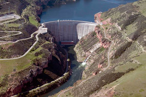
Yellowtail Dam
| Yellowtail Dam at Bighorn Lake |
|||||||||
|---|---|---|---|---|---|---|---|---|---|
| The dam of the Yellowtail Dam | |||||||||
|
|||||||||
|
|
|||||||||
| Coordinates | 45 ° 18 '28 " N , 107 ° 57' 27" W | ||||||||
| Data on the structure | |||||||||
| Construction time: | 1961-1966 | ||||||||
| Height above foundation level : | 160 m | ||||||||
| Height of the structure crown: | 1115.57 m | ||||||||
| Building volume: | 1.1817 million m³ | ||||||||
| Crown length: | 451 m | ||||||||
| Crown width: | 6.7 m | ||||||||
| Base width: | 44.8 m | ||||||||
| Power plant output: | 4 × 66 MW | ||||||||
| Data on the reservoir | |||||||||
| Altitude (at congestion destination ) | 1115.57 m | ||||||||
| Reservoir length | 114 km | ||||||||
| Storage space | 1761 million m³ | ||||||||
| Catchment area | 50 893 km² | ||||||||
The Yellowtail Dam was built between 1961 and 1966 by the Bureau of Reclamation in Montana ( USA ). It is located near Fort Smith and 45 miles southwest of Hardin in Big Horn County . The dam is named after Robert Yellowtail , a famous chief of the Crow Indians .
The dam , with its arch dam one of the highest in the Missouri River basin , dams the Bighorn River to Bighorn Lake , one of the largest reservoirs in the Missouri area. It is the main attraction of the Bighorn Canyon National Recreation Area , which is under the administration of the National Park Service . Its shoreline is more than 300 km long.
The dam serves as a water reservoir , flood protection , hydropower generation, irrigation , water supply for industry, fishing, sediment control and recreation.
The project was decided in the Flood Control Act of December 22, 1944.
See also
- List of the largest dams on earth
- List of the largest reservoirs on earth
- List of the largest hydroelectric plants in the world
- List of dams in the United States


