Bighorn River
|
Bighorn River upper reaches: Wind River |
||
|
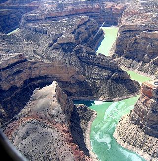
Bighorn Canyon |
||
| Data | ||
| Water code | US : 779903 | |
| location | Montana , Wyoming (USA) | |
| River system | Mississippi River | |
| Drain over | Yellowstone → Missouri → Mississippi → Gulf of Mexico | |
| Renaming point |
Wedding of the Waters , above the Wind River is called 43 ° 44 ′ 50 ″ N , 110 ° 4 ′ 27 ″ W |
|
| Source height | 1330 m | |
| muzzle | in the Yellowstone River coordinates: 46 ° 9 ′ 18 " N , 107 ° 28 ′ 28" W 46 ° 9 ′ 18 " N , 107 ° 28 ′ 28" W. |
|
| Mouth height | 819 m | |
| Height difference | 511 m | |
| Bottom slope | 1.2 ‰ | |
| length | 444 km (including Wind River : 742 km) | |
| Catchment area | 59,272 km² | |
| Discharge at the gauge near St. Xavier A Eo : 50,928 km² |
MQ 1935/2016 Mq 1935/2016 |
96 m³ / s 1.9 l / (s km²) |
| Left tributaries | Greybull River , Shoshone River | |
| Right tributaries | Little Bighorn River , Nowood River | |
| Reservoirs flowed through | Bighorn Lake | |
| Small towns | Thermopolis , Worland , Hardin | |
|
Course of the Bighorn River |
||
|
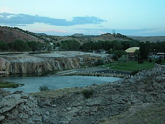
Travertine deck on the Bighorn River, Hot Springs State Park in Thermopolis |
||
|
Bighorn River in Montana |
||
The Bighorn River is a 444 km ( 742 km including Wind River ) tributary of the Yellowstone River in the US states of Wyoming and Montana . About 7 km south of Thermopolis there is a point above which the river is called the Wind River .
Surname
As Europeans, the river in Montana arrived, they called him about the occurring there bighorn sheep (Engl. Bighorn Sheep ). In contrast, explorers in what is now Wyoming gave the river the name Wind River. Only later did it become apparent that they were one and the same body of water. To end the confusion that has arisen, it was decided that the river should change its name from an arbitrarily determined point. This is located at the exit of the Wind River Canyon , around seven kilometers south of Thermopolis and is called Wedding of the Waters . Here is one of those rare places where a river suddenly has a different name for no apparent reason.
course
The Bighorn River rises as a Wind River in the Wind River Range , south of the Owl Creek Mountains . First it flows in a south-easterly direction through the Wind River Basin , from Riverton it turns north. Before the Wind River in the Wind River Canyon cuts through a mountain range (west: Owl Creek Mountains , east: Bridger Mountains ), it is dammed up to form the Boysen Reservoir . At the exit of the gorge, the river passes the Wedding of the Waters point and is called the Bighorn River from there. It then flows through the town of Thermopolis and past Hot Springs State Park . The river then flows through the Bighorn Basin in a northerly direction. The Yellowtail Dam in Bighorn Canyon dams the river to Bighorn Lake , which cuts the border with the state of Montana and forms the core of the Bighorn Canyon National Recreation Area . It then flows through the Crow Indian Reservation before reaching the Yellowstone River below Custer .
Bighorn Basin
The Bighorn River drains the Bighorn Basin named after it, a high plateau at an average of around 1325 m above sea level. It lies between the Big Horn Mountains to the east and the Absaroka Range to the west. The basin was originally inhabited by the Eastern Shoshone and Absarokee Indians (also known as the Crow Indians). The first white man in the area was John Colter , who in 1807 discovered Colter's Hell , an area of volcanic activity on the Shoshone River . In 1864 Jim Bridger explored the basin as a route for the way from the Oregon Trail to Montana when the Bozeman Trail, which runs parallel to the east, was not passable due to conflicts with the Lakota Indians. The river was also called the Great Horn River or Le Corne (for "Horn") in French by pioneers .
Around the turn of the 20th century, the basin was slowly being settled by ranchers . The leader was William Cody, who had become famous as Buffalo Bill and from 1896 developed the place Cody to market his celebrities . Butch Cassidy formed his infamous gang, the Wild Bunch , in the area in 1897 after serving in prison and used the Hole in the Wall in the Big Horn Mountains as a hideout.
Web links
Individual evidence
- ^ Wind River in the Geographic Names Information System of the United States Geological Survey
- ↑ a b Bighorn River in the Geographic Names Information System of the United States Geological Survey
- ↑ USGS 06287000 Bighorn River near St. Xavier, MT
- ^ Wedding of the Waters Historical Marker
- ↑ Bighorn River in the Geographic Names Information System of the United States Geological Survey


