
Hot Springs State Park
|
Hot Springs State Park
|
||
 Steaming hot springs and the swinging bridge |
||
| location | Hot Springs County in Wyoming (USA) | |
| surface | 420 ha | |
| Geographical location | 43 ° 39 ′ N , 108 ° 12 ′ W | |
|
||
| Setup date | 1897 as Big Horn Hot Springs State Reserve | |
| administration | Wyoming Division of State Parks and Historic Sites | |

The Hot Springs State Park is adjacent to the northwest of Thermopolis in the Hot Springs County of the US state of Wyoming . The park was established in 1897 and is 420 hectares (or 1,039 acres ) in size. The elevation gain within the state park is between 1,458 m on T Hill and 1,320 m.
The hot mineral springs in the park have a discharge of 300 hectoliters per day. Part of the constantly 53 ° C warm water is channeled into pools to cool down before it is used at 40 ° C by the adjoining bathing establishment for therapeutic purposes. The other part flows via travertine cascades into the Bighorn River , which crosses the park from south to north. A suspension bridge for pedestrians, called The Swinging Bridge, connects the two banks with a 10 km barrier-free network of paths.
The park also has a herd of bison with 24-27 adult animals and between 10 and 15 calves.

Swinging Bridge over the Bighorn River and travertine cascades

Travertine cascades, boat ramp, park and bathing establishment
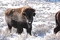
Bison in Hot Spring State Park


Individual evidence
- ↑ Archive link ( Memento of the original from March 24, 2012 in the Internet Archive ) Info: The archive link was inserted automatically and has not yet been checked. Please check the original and archive link according to the instructions and then remove this notice.
- ↑ http://www.wildernet.com/pages/area.cfm?areaID=WYSPHOT