Blüemlisalpfirn
| Blüemlisalpfirn | ||
|---|---|---|
|
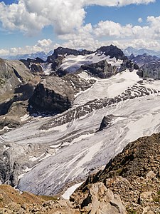
Rot Gitschen and Blüemlisalpfirn (in the background) from Engelberger Rotstock |
||
| location | Isenthal municipality , Uri canton , Switzerland | |
| Mountains | Uri Alps | |
| length | 2 km | |
| surface | 2.1 km² | |
| Altitude range | 2850 m above sea level M. - 2300 m above sea level M. | |
| width | Max. 1 km | |
| Coordinates | 683 218 / 189.06 thousand | |
|
|
||
| drainage | Isentalerbach | |
The Blüemlisalpfirn is a glacier at the head of the Isental valley on the floor of the municipality of Isenthal in the canton of Uri in Switzerland .
The approx. 2 km long and maximum 1 km wide glacier covers an area of around two square kilometers and is located on the northern slopes of the Brunnistock and the Blackenstock in the Uri Alps . This makes it the largest glacier in the Isental Valley and the Uri Alps north of the Surenen Pass . In the vicinity of its glacier tongue, which extends up to approx. 2300 m above sea level. M. reaches down, is the Gitschenhörelihütte , which is often used for alpine tours in the area. The glacier is drained by the Isentalerbach .
The Blüemlisalpfirn is far away from the Blüemlisalp mountain range in the Bernese Oberland.
Web links
- Blüemlisalpfirn at ortsnames.ch
Individual evidence
- ↑ Gitschenhörelihütte. Retrieved March 27, 2020 .

