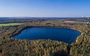
Boisdorf Lake
| Boisdorf Lake | ||
|---|---|---|

|
||
| Boisdorf Lake | ||
| Geographical location | Rhein-Erft-Kreis , North Rhine-Westphalia , Germany | |
| Tributaries | Small Erft | |
| Drain | Small Erft | |
| Location close to the shore | Kerpen , cheeky | |
| Data | ||
| Coordinates | 50 ° 53 '37 " N , 6 ° 43' 53" E | |
|
|
||
| surface | 17 ha | |
| volume | 1.5 million m³ | |
| Maximum depth | 24 m | |
|
particularities |
||

|
||
| Map of the Villeseen | ||
The Boisdorfer See is a residual open pit lake that was created in a hollow during the recultivation of the former Frechen opencast mine . The lake is named after the former Kerpen district of Boisdorf , which was excavated when the open-cast mine was burned out in 1975 and was roughly at the site of today's lake.
The lake is around 24 m deep, 17 hectares in size and has a volume of around 1.5 million m³. The artificial lake is fed by the Kleine Erft ; the area around the lake also serves the Erftverband as a flood retention basin for the river. The lake and its surroundings are used for local recreation . He stands in the ecological network with the Kerpener fracture and subsequent Marienfeld and is part of the framework of the Regionale 2010 designed Regio Green in the Rhineland Nature Park . A circular path around the lake and a wider church path , which connects the former town centers of the excavated and relocated districts, and the Quirinus hiking path through Marienfeld are connected to long-distance hiking trails, such as the Erft cycle path or the Jacobsweg via Cologne and Aachen .
See also
Individual evidence
- ↑ a b c d Kölner Stadtanzeiger: The new lake is full to the brim
- ↑ RWE brochure: Destination Marienfeld (PDF)
- ↑ Flood retention basin Mödrath at www.erftverband.de ( page no longer available , search in web archives ) Info: The link was automatically marked as defective. Please check the link according to the instructions and then remove this notice.
