
Bontoc (Mountain Province)
| Municipality of Bontoc | |||
| Location of Bontoc in the Province of Mountain Province | |||
|---|---|---|---|

|
|||
| Basic data | |||
| Region : | Cordillera administrative region | ||
| Province : | Mountain Province | ||
| Barangays : | 16 | ||
| District: | 1st District of Mountain Province | ||
| PSGC : | 144404000 | ||
| Income class : | 3rd income bracket | ||
| Households : | 5035 May 1, 2000 census
|
||
| Population : | 24,643 August 1, 2015 census
|
||
| Coordinates : | 17 ° 5 ′ N , 120 ° 59 ′ E | ||
| Postal code : | 2616 | ||
| Area code : | +63 74 | ||
| Mayor : | Franklin Chaoka's Odsey | ||
| Website: | www.bontoc.gov.ph | ||
| Geographical location in the Philippines | |||
|
|||

Bontoc is a municipality in the Province of Mountain Province, Philippines . It has 24,643 inhabitants (August 1, 2015 census).
Bontoc is the seat of the provincial government of Mountain Province.
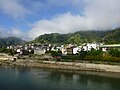
The city is located in the Philippine Cordilleras in the valley of the Chico River .
The Bontoc Museum , founded by a Belgian nun, documents the life of the hill tribes in the area, the Igorot , including Kalinga, Isneg, Apayao, Ifugäo, Ibaloi, Tingulan and Bontoc from the villages of Sagada, Sadanga, Tuocan and Mainit, among others. The Bontoc petroglyphs can be found in Barangay Alab .
There is the Mountain Province State Polytechnic College in town.
The "Halsema Highway" connects the city with Mount Data National Park and with Baguio in the south and with Sadanga and Tinglayan in the north. Sagada is 5 km to the west , and the Maligcong rice terraces are 2 km to the north. The Patoc volcano lies on the territory of the municipality .
Administrative structure
Bontoc is politically divided into 16 barangays .
|
|
|
|
Web links
gallery
Bontoc

Samoki Bridge over the Chico


Individual evidence
- ↑ http://bontoctourism.com/?p=1074 ( page no longer available , search in web archives ) Info: The link was automatically marked as defective. Please check the link according to the instructions and then remove this notice.
- ↑ http://whc.unesco.org/en/tentativelists/5018/