
Filipino Cordilleras
| Filipino Cordilleras | |
|---|---|
 Topographic map showing the |
|
| Highest peak | Pulag ( 2928 m ) |
| location | Luzon , Philippines |
| part of | Luzon island |
| Coordinates | 17 ° 0 ′ N , 121 ° 30 ′ E |
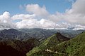
The Philippine Cordilleras are a mountain range formed from several mountain ranges on the main island of Luzon in the Philippines . A distinction is made between the western cordillera ( Zambales mountains ), the middle cordillera (Cordillera Central) and the eastern cordillera ( Sierra Madre ). The Caraballo Mountains, located between Sierra Madre and Cordillera Central, are the central mountain knot of the Philippine Cordillera.
Cordillera Central

The Cordillera Central is the most extensive mountain country on the island of Luzon, can be distinguished three major chains: In the western coastal cordillera (Malayakette) followed by the Central Range (Cordillera Central) and the Polis chain . In the Malaya chain running in the west, the greatest heights are around 1800 m compared to the main axis of the mountainous region, the Central Cordillera, which has heights of over 2700 m. The further east running polis chain with the highest elevations in Luzon, the Pulag (2922 m). Around the Pulag, the Mount Pulag National Park was established in 1987 on an area of 11,550 hectares. All mountain ranges experience a slope to the north up to 1000 m in the coastal area, the highest elevations are in the southern part.
Caraballo Mountains

The Caraballo Mountains separate the central Luzon plain, in which the Pampanga flows, from the Cagayan Valley. This hilly, wide-angled mountainous country , which reaches heights of 1680 m, has also been referred to as the central mountain junction, as the Cordillera Central of northern Luzon is linked here with the Sierra Madre . The Caraballo Mountains form the watershed between the Cagayan tributaries and the Pampanga, which drains large parts of the plains from central Luzon to Manila Bay.
Eastern Cordillera (Sierra Madre)
The Sierra Madre, approaching from the northeast, turns further south in a north-south direction and is now referred to as the Eastern Cordillera. The highest mountain in the Sierra Madre is the 1850 meter high mountain Anacuao . Like the Sierra Madre and the central mountain junction, the Carballo Mountains, the Eastern Cordillera of Luzon has also been little explored. Basement material, andesites and Miocene limestone are the most important building materials. The height of the mountains gradually decreases towards the south, and the width of the mountains becomes smaller. Southeast of the Laguna de Bay one can only speak of a hill country. The most important nature reserve in the Sierra Madre is the Northern Sierra Madre Natural Park . In the area of the central Sierra Madre is the Angat reservoir , from which over 90% of the drinking water for the metropolitan area of Metro Manila is taken.
Western Cordillera (Zambales Mountains)
The Zambales Mountains form the western front of the Philippine Cordilleras. The shapes of the mountains are very different; in the north, where the foothills extend into the peninsula bordering the Gulf of Lingayen in the west, there are extensive flat areas in the low-lying, flat hill country. In the width of Lingayen begins the actual mountain country, which very quickly reaches heights of 1000 m. The centrally located largest elevations reach 2037 meters on Mount Tapulao .
climatology
The Philippines has a tropical maritime climate ("sultry greenhouse climate"), which is characterized by high and constant average temperatures (20–30 ° C), extreme humidity and high levels of precipitation (10 to 12 humid months). It is mainly determined by the monsoon wind regime, which roughly divides the year into two hygric halves: the rainy season and the dry season. From November to April the relatively dry northeast monsoon dominates and from May to October the more humid southwest monsoon dominates. The mean monthly temperatures in the lowlands are between 25 ° C in December and January and 29 ° C in May, the hottest month. The annual rainfall amounts to 2000 mm / year, whereby they vary greatly from region to region. In the east of northern Luzon there is about 3500 mm / year without a proper dry season. In the west, 1500 to 2000 mm are measured annually. It rains most there during the southwest monsoon (between May and October). The northeast monsoon (between November and April) brings rather dry air in.
In the Filipino Cordilleras, one can differentiate between three different seasons, although the cycle does not always occur constantly and the altitude of the area is responsible for the temperature distribution: the rainy season (June to November), the cool dry season (December to February) and the hot dry season (March to May). In the cool dry season, the temperatures in the highlands near Baguio (1500 m altitude) drop to 6 degrees Celsius and at even higher altitudes, ground frosts can occur.
Rough classification of the climatic zones of the Philippine Cordillera:
- West coast of the Zambales Mountains : Typical Southeast Asian monsoon climate with a long dry season
from November to May and an intense rainy season from June to December.
- Inland Cagayan Valley: Short dry season from March to May and less intense rainy season
from June to February.
- East coast Sierra Madre: No pronounced dry season, most rain falls from November
until January.
National parks and protected areas in the Philippine Cordilleras
Mount Pulag National Park , Northern Sierra Madre Natural Park , Mount Data National Park , Balbalasang Balbalan National Park , Angat Watershed Forest Reserve , Tirad Pass National Park with the national memorial in honor of Gregorio del Pilar , Kalbario Patapat National Park , Peñablanca Protected Landscape & Seascape , Cassamata Hill National Park , Fuyot Spring National Park , Minalungao National Park , Bangan Hill National Park , Salinas Natural Monument , Bessang Pass Natural Monument , Pamitinan Protected Landscape , Marikina Watershed Forest Reserve
Volcanic activities
There are only two active volcanoes in the Filipino Cordilleras: Pinatubo , which last erupted between 1991 and 1995, and Cagua, 1135 meters high, in the north of the Sierra Madre, which last erupted in 1860 . Three other volcanoes are designated as potentially active, the Mariveles , the Natib and the Patoc .
gallery
Filipino Cordilleras

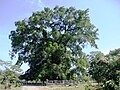
a 600 year old balete tree in the Sierra Madre


