Natib
| Mount Natib | ||
|---|---|---|
|
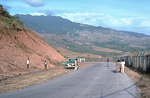
View of Mt. Natib |
||
| height | 1253 m | |
| location | Luzon Island , Philippines | |
| Mountains | Zambales Mountains , Filipino Cordillera | |
| Coordinates | 14 ° 42 '43 " N , 120 ° 24' 4" E | |
|
|
||
| Type | Stratovolcano | |
| rock | Andesite , dacite | |
The Mount Natib is an extinct stratovolcano , a height of 1,253 meters above sea level reached. It is located in the Zambales Mountains , in the northern region of the Bataan Peninsula in the Bataan National Park , south of the Pinatubo volcano . In the summit area of the Natib there is a 6 × 7 km caldera and the smaller Pasukulan caldera.
An eruption of the Natib is not known, but it is believed that the last eruption occurred in the late Pleistocene or early Holocene , further investigation and dating is pending. The Mamot , Tigulangin , Uyong and Paipit Springs, several thermal springs with water temperatures between 30 and 56 ° C, are located in the area of the Natib .
The Natib is classified as “potentially active” by the Philippine Institute of Volcanology and Seismology.
Web links
- Natib in the Global Volcanism Program of the Smithsonian Institution (English)
- https://sites.google.com/a/bataan.gov.ph/tourism/mt-natib
- Philippine Institute of Volcanology and Seismology

