Boulder, Utah
| Boulder | ||
|---|---|---|
 Boulder |
||
| Location in Utah | ||
|
|
||
| Basic data | ||
| Foundation : | 1890 | |
| State : | United States | |
| State : | Utah | |
| County : | Garfield County | |
| Coordinates : | 37 ° 54 ′ N , 111 ° 25 ′ W | |
| Time zone : | Mountain ( UTC − 7 / −6 ) | |
| Residents : | 223 (as of 2014) | |
| Population density : | 4.1 inhabitants per km 2 | |
| Area : | 54.2 km 2 (approx. 21 mi 2 ) of which 54.2 km 2 (approx. 21 mi 2 ) is land |
|
| Height : | 2043 m | |
| Postal code : | 84716 | |
| Area code : | +1 435 | |
| FIPS : | 49-07470 | |
| GNIS ID : | 1437510 | |
| Website : | boulder.utah.gov | |
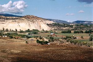
Boulder is a village on the edge of the Grand Staircase-Escalante National Monument in Garfield County in Utah , USA . It is the starting point of the Burr Trail and Utah State Route 12 runs through it . In 2014 Boulder had 223 inhabitants, the area of the city is 54.2 km².
age structure
The average age is 34 years.
| Years | proportion of |
|---|---|
| under 18 | 30.0% |
| 18 - 24 | 11.1% |
| 25-44 | 26.7% |
| 45-64 | 21.1% |
| over 65 | 11.1% |
history
Boulder is still home to the old mail trail that was used to transport mail until Boulder was the last city in the United States to have a road connection. Electricity has only been around since 1947; the first telephone line was laid in 1910.
Web links
Commons : Boulder, Utah - Collection of images, videos, and audio files

