Bragança (Pará)
| Bragança | ||
|---|---|---|
|
Coordinates: 1 ° 4 ′ S , 46 ° 46 ′ W Bragança on the map of Pará
|
||
| Basic data | ||
| Country | Brazil | |
| State | Pará | |
| City foundation | 1613 | |
| Residents | 126,436 (2018 estimate) | |
| City insignia | ||
| Detailed data | ||
| surface | 2098.144 | |
| Population density | 60 people / km 2 | |
| height | 19 m | |
| Post Code | 68600-000 | |
| prefix | (+55) 91 | |
| Time zone | UTC −3 | |
| City Presidency | João Nelson Pereira Magalhães (PT) | |
| Website | ||
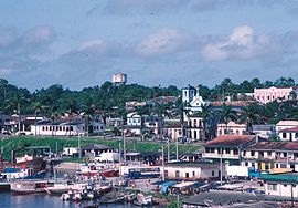
| View of Bragança with a view of parts of the port, the São Benedito Church (18th century) and the prefecture (town hall / district administration) | ||
Bragança is a port city on the banks of the Rio Caeté in the northeast of the Brazilian state of Pará . Bragança is the administrative seat of the district of the same name ( município ). The larger towns in the district include Almoço, Caratateua, Nova Mocajuba, Piabas and Tijoca.
history
The city goes back to a village founded in 1634 on the east bank of the Rio Caeté and is one of the oldest, along with the capital of the state of Pará , Belém (founded 1616), and the city of Vigia on the Bay of Marajó (also around 1616) Portuguese settlements of the region. Later, Bragança was rebuilt on the western bank of the river. Bragança was not recognized as a city until 1854.
Economy and tourism
Bragança is of regional importance as a fishing port. Agriculture in the Bragança district focuses on the cultivation of cassava , beans and rice , citrus fruits and bananas are also harvested. In addition to the district administration, trade and banking, handicrafts, the catering and hotel industry as well as companies in the field of fishing are important employers. Most of the population lives in poor conditions.
Bragança is a popular destination for the residents of Belém, particularly because of the beach resort of Ajuruteua ( 0 ° 50 ′ S , 46 ° 36 ′ W ) on the Atlantic coast north of the city . The São Benedito Festival (in December; since 1798), originally celebrated by slaves, with its traditional, colorful costumes and the dance of the marujada has also become a tourist attraction.
Web links
- http://www.pa.gov.br/conhecaopara/braganca.asp Website of the state of Pará on Bragança (in Portuguese )
- http://www.ibge.gov.br Statistics from Instituto Brasileiro de Geografia e Estatística (IBGE; in Portuguese )
- http://www.braganca.pa.gov.br/ Bragança Prefecture website (in Portuguese )
- http://turismo.braganca.pa.gov.br/ Website of the Bragança Tourism Secretariat (in Portuguese )
Individual evidence
- ^ Brazilian Institute of Geography and Statistics . 2018. Retrieved March 6, 2019: "2018 Estimates of Population"


