Brodenbach (Moselle)
| Brodenbach | ||
|
The Donnerloch cascade group on an old postcard |
||
| Data | ||
| Water code | DE : 26994 | |
| location | Rhineland-Palatinate , Germany | |
| River system | Rhine | |
| Drain over | Moselle → Rhine → North Sea | |
| source | At Buchholz 50 ° 12 ′ 56 ″ N , 7 ° 32 ′ 9 ″ E |
|
| Source height | approx. 372 m above sea level NN | |
| muzzle | In Brodenbach coordinates: 50 ° 13 '47 " N , 7 ° 26' 49" E 50 ° 13 '47 " N , 7 ° 26' 49" E |
|
| Mouth height | approx. 73 m above sea level NN | |
| Height difference | approx. 299 m | |
| Bottom slope | approx. 36 ‰ | |
| length | 8.2 km | |
| Catchment area | 15.674 km² | |
| Communities | Brodenbach | |
The Brodenbach is an 8.2 km long orographically right tributary of the Moselle in Rhineland-Palatinate , Germany .
geography
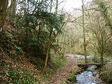
The source of the Brodenbach lies in the north of the Buchholz district of Boppard at approx. 372 m above sea level. NN . From there it flows through a narrow valley in a predominantly westerly direction, without crossing any other villages. The narrowest section is known as the “Donnerloch”, a cascade group that has only been partially preserved for a forestry road since it was blown up in the 1960s. Only short watercourses flow into the Brodenbach on both sides. It flows in the north of the town of Brodenbach at 95 m above sea level. NN in the Moselle .
The 8.2 km long course of the river overcomes an average bed gradient of 45.4 ‰ 299 meters in altitude and drains an area of 15.674 km².
The entire Bachtal is only accessible to traffic through hiking trails and partially developed farm roads. The green mill on the middle of the stream is the only settlement.
On the narrow, shaded lower course there is a large occurrence of the very poisonous European yew on the slate rocky steep slopes . In the valley slopes, which are mainly overgrown with oak, the yew trees grow in particularly rocky, light-poor places.
Tributaries

- Lehnscheider Bach - 0.9 km long, right tributary at 282 m above sea level. NN
- Buchholzer Bach - 1.2 km long, left tributary at 276 m above sea level. NN
- Höllebach - 1.3 km long, right tributary at 261 m above sea level. NN
- Bickelbach - 0.9 km long, left tributary behind Ohlenfeld at 251 m above sea level. NN
- Elmsgraben - 0.9 km long, left tributary at 241 m above sea level. NN
- Kohlbach - 2.8 km long, right tributary at 202 m above sea level. NN
- Herschwieser Bach
According to the recording of the Land Surveying Office, the Brodenbach does not arise until the confluence of the Lehnscheider Bach and the Ohlenbach, which arise in the district of Buchholz in the city of Boppard.
See also
swell
- Topographic map 1: 25,000
- Ministry for the Environment, Forests and Consumer Protection Rhineland-Palatinate (length and catchment area)

