
Bucher Cave (Dillberg)
| Bucher cave
|
||
|---|---|---|
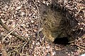
 Entrance Bucher Caves |
||
| Location: | Dillberg, Franconian Alb , Germany | |
|
Geographic location: |
49 ° 19 ′ 29.5 " N , 11 ° 22 ′ 29.5" E | |
|
||
| Cadastral number: | K 44 | |
| Geology: | Dogger | |
| Type: | Artificial cave | |
| Lighting: | No | |
| Overall length: | 70 meters | |

The Bucher Höhle (n) is an artificial cave near the Upper Palatinate Postbauer-Heng in the Neumarkt district in Upper Palatinate in Bavaria .
location
The cave is located a little below the Dillberg plateau , about 2400 meters northeast of Postbauer-Heng . It is the northernmost cave in the karst area K of the Franconian Alb .
description
The Bucher cave is also called the Dillberg cave or the silver sand cave . These are actually several man-made caves, but only one of them is easily accessible. The other caves are filled in or have collapsed. The still accessible cave has two entrances. The small cave system is branched inside. After the snow melts or longer rains, the cave is partially under water. The cave has been identified as a valuable geotope (373G004) by the Bavarian State Office for the Environment . It is registered as cave K 44 in the Franconian Alb cave cadastre (HFA).
history
The caves were carved into the sandstone by farmers and their farmhands during the winter months between the First and Second World Wars . The fine-grained quartz sand that was extracted was brought to the Postbauer-Heng station by cart and loaded onto freight wagons. Customers were Nuremberg companies that processed the sand into abrasives or cleaning sand. In 1945 the caves served as a shelter for the Buch population in the last weeks of the war.
Access
The cave is freely accessible all year round. The entrance is at ground level. There are no dangerous spots in the cave. The cave can only be reached on foot via a hiking trail from Buch, which is marked with a white 1 on a red background. Due to the protection of the caves and the bats that hibernate there , it is not accessible from October to April.
Picture gallery

Inside the Buch cave
Another cave that is difficult to access

Information board


Individual evidence
- ↑ Geotope: Bucher Silbersandhöhlen on the Dillberg NNE from Buch (accessed on March 11, 2020)
- ↑ Cadastral information ( Memento of the original from February 21, 2014 in the Internet Archive ) Info: The archive link was inserted automatically and not yet checked. Please check the original and archive link according to the instructions and then remove this notice. (Accessed April 21, 2013; PDF; 1.4 MB)