
Dillberg
| Dillberg | ||
|---|---|---|
 |
||
| height | 595 m above sea level NN | |
| location | District of Neumarkt in the Upper Palatinate , Bavaria ( Germany ) | |
| Mountains | Franconian Alb | |
| Coordinates | 49 ° 19 '28 " N , 11 ° 22' 54" E | |
|
||
| Type | Zeugenberg | |
| particularities | Broadcasting station of the Bavarian Radio | |


The Dillberg is about 595 m above sea level. NN high hilltop of the Franconian Alb in the municipality of Postbauer-Heng in the district of Neumarkt in the Upper Palatinate , Bavaria ( Germany ).
geography
location
The Dillberg is located in the western part of the Upper Palatinate Jura , the part of the Franconian Jura (Franconian Alb) in the Upper Palatinate . It is part of around Neumarkt in der Oberpfalz extending witnesses mountains of the Swabian Alb. To the east, a little below its gently arched hilltop, lies the Dillberg district of the market town of Postbauer-Heng. Part of the European watershed runs over the Dillberg, which is not forested on its top .
geology
The distinctive witness mountain of the Franconian layered landscape shows a typical geological structure. The plateau consists of layers of the White Jura (Malm). The remains of the Weißjura on the summit of the Dillberg are shaped by rocks from the Hartmannshof formation. Small areas occur Massenkalk or reef dolomite evident. Alblehm was deposited in the Tertiary and Quaternary as a top layer and as a filling in the karst hollow forms of the Malm . The rocks of the White Jura lie on Dogger strata ( Brown Jura ). These rocks of the iron sandstone formation consist of thick layers of sandstone . Below that is the soft and clay-rich layer of the Opalinus Clay in the Lower Dogger (Brown Jura). The lowest level of the Dillberg consists of layers of Liass ( Black Jura ).
ground
The summit of the Dillberg is covered with brown earth . These fertile locations are used intensively for agriculture. Among them include flat ground, and carbonate -rich Rendzina -floors on. At the foot of the mountain there are Regosol and brown earth Regosol soils.
Possibility of viewing
The Dillberg offers a good panoramic view, especially to the west in the direction of Middle Franconia , for example to the Nuremberg telecommunications tower 27 kilometers away .
When visibility is good, the Kammerstein transmitter south of Schwabach can be seen with the naked eye .
The slopes of the eastern part of the Swabian Alb can be seen with optimal visibility, or the north-eastern slopes of the southern Franconian Alb . The Hesselberg is then also visible.
The northwest are next to the Nuremberg Castle to see the outlines of the old town, and in the east of Nuremberg located Business Tower . To the north the view is slightly interrupted by a foothill.
To the northeast, the south-western slopes of Franconian Switzerland , as well as the cities of Lauf and Altdorf can be seen. In addition, the Dillberg offers a good view of the Moritzberg . The gaze wanders eastwards towards Pegnitz and southern Upper Franconia .
The view leads far into the valley between Altdorf and Berg . Only parts of the Neumarkt basin can be seen from the summit plateau, as the Heinsberg with the Heinrichsbürg castle ruins somewhat obscures the view of the district town. The former US radar station near Lauterhofen , the area from Lauterhofen to Velburg and the transmitter on the Göschberg near Seubersdorf , 23 kilometers away, can be seen. The Wolfstein castle ruins and the Mariahilf pilgrimage church near Neumarkt are also visible . To the south, the valley from Neumarkt towards Sengenthal (former quarry) and the mountains south and south-east of Neumarkt in the Upper Palatinate can be seen.

useful information
The Dillberg transmitter , which has been operated by Bayerischer Rundfunk since 1955 and whose main mast (built in 1990) is 231 meters high, is located on the Dillberg .
At the foot of the Dillberg, the sheet gold cone from Ezelsdorf-Buch was found in 1953 . There is the Wurzhof, a facility for the mentally handicapped of the Rummelsberger Anstalten .
“Silver sand” used to be mined around the Dillberg. Some silver sand caves are still visible today. The largest cave, the Bucher Höhle or Dillberghöhle ( cave register Franconian Alb , cadastral number K 44) is in the immediate vicinity of the hiking trail to Buch.
The former Hotel Berghof, which was damaged by vandalism and a fire, was located on the plateau until 2013 . In spring 2013 an investor showed interest in the site. The Berghof was finally demolished in mid-2013.

The Berghof in April 2013

The Berghof in June 2013
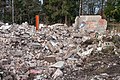
The Berghof in January 2014


Furthermore, on the northeastern mountain area, between the hamlet of Kleinvoggenhof and Doktorshof, there is a section of a modern line of fortifications, the so-called Kurbayerische Landesdefensionslinie. It was created in 1702 during the War of the Spanish Succession (1701–1704). Today they are a ground monument .
On the grounds of the Dill Mountain and the neighboring Brent mountain was in the Middle Ages mining operation. In cooperation with the State Office for the Preservation of Monuments , research into this area began in 2012.
Protected areas
Landscape protection area
The 1,916 hectare landscape around the Zeugenberg is designated as the Dillberg-Heinrichsberg landscape protection area (LSG00553.01) and protected by the Protection Area Ordinance of July 25, 2001.
Geotope
The geotope Sandgrube am Gitzberg (373A001), designated by the Bavarian State Office for the Environment , is located about 1500 meters southeast of the Dillberg . Due to its exposure, the area offers a good insight into the layers of the Doggersandstein . The sand pit is still being managed and part of the outcrops has already been backfilled.

Say

There are many legends about the Dillberg. It should have underground caves or there should be an underground city on the Dillberg. Most of the legends date from the time of the Huns . When their king Attila died on their retreat through Germany , the savage peoples of the war looked for a suitable place to bury their dead military leader. The Dillberg supposedly seemed suitable for this. There they built a burial chamber and buried their King Attila, also called Etzel, in 453 AD. The area is also repeatedly associated with the legendary Eppelein treasure.
leisure

Several circular and target hiking trails lead over and around the Dillberg. On the Dillberg plateau itself, the Path of Poetry hiking trail leads to various art and architectural monuments. There is no gastronomy on the Dillberg.
See also
Individual evidence
- ↑ UmweltAtlas Bayern Geologie - digital geological map of Bavaria 1: 25,000 (dGK25). Bavarian State Office for the Environment, accessed on July 22, 2018 .
- ↑ Gottfried Hofbauer: The witness mountains around Neumarkt and their significance in the development of the layered landscape south of Nuremberg. In: Annual Reports 2010 Nuremberg 2011. Naturhistorische Gesellschaft Nürnberg eV, 2010, accessed on July 22, 2018 .
- ^ BayernAtlas - overview soil map of Bavaria 1: 25,000 (overview soil map 1: 25,000). Bavarian State Office for the Environment, Bavarian Surveying Administration, accessed on July 22, 2018 .
- ↑ Berghof: Miniature poodle instead of brothel (accessed on April 18, 2013).
- ↑ Recording of ground monuments on Brentenberg and Dillberg ( Memento from February 19, 2014 in the Internet Archive ) (accessed on April 18, 2013).
- ↑ Green list of landscape protection areas in the Upper Palatinate. Bavarian State Office for the Environment, 2017, accessed on July 22, 2018 .
- ↑ BayernAtlas - Environment. Bavarian State Office for the Environment, Bavarian Surveying Administration, accessed on July 22, 2018 .
- ↑ Landscape protection areas. District of Neumarkt in der Oberpfalz, accessed on July 22, 2018 .
- ↑ Geotope: Sandgrube am Gitzberg (accessed on January 17, 2014).
- ↑ Eppelein, gold cone and Gold Rush ( Memento of 25 February 2014 Internet Archive ).
- ↑ Weg der Poesie, Flyer ( Memento from June 20, 2012 in the Internet Archive ) (Accessed April 19, 2013; PDF; 3.2 MB).