
Franconian Alb
| Franconian Alb (Franconian Jura / Franconian Jura / Franconian Jura) |
|
|---|---|
 Franconian Alb |
|
| Highest peak | Dürrenberg ( 656.4 m above sea level ) |
| location | Bavaria |
| part of | Southwest German layer level country |
| Classification according to | Handbook of the natural structure of Germany / Federal Agency for Nature Conservation |
| Coordinates | 49 ° 1 ′ N , 10 ° 46 ′ E |
| Type | Low mountain range , layer level |
| surface | 7,053.8 km² |
The Franconian Jura , also Frankenalb , Franconian Jura or Frankenjura called, is one to 656.4 m above sea level. NHN , in the outlying foothills ( Hesselberg ) even up to 689.4 m high low mountain range , which belongs to the south-west German layer level country in Bavaria and extends the even higher Swabian Alb beyond the Nördlinger Ries to the east-northeast and finally to the north-northwest. It is 7053.8 km² in size.
On the edge of the Franconian Alb are the places Ingolstadt (south), Regensburg (south-east), Nuremberg (west of the north-east), Bamberg (north-west) and Bayreuth (north-east).
Name origin
The name Alb was previously derived from the Latin expression montes albi (white mountains). More likely it is an old Celtic name and means mountain pasture .
geography
location
The Franconian Jura stretches in north-south-west direction from Lichtenfels on Main past Bamberg and Nuremberg in the west and Bayreuth and Regensburg in the east and Ingolstadt on the Danube in the south to the eastern edge of the Wörnitz carrying meteorite crater Ries , through which they of the west adjoining Swabian Alb is separated. Its highest point is the 656 m high Dürrenberg on the Hahnenkamm in the extreme northwest of the southern part.
Natural structure

The Federal Institute for Regional Studies has since the 1950s in the Handbook of the Natural Region Divisions of Germany and in subsequent single sheets 1: 200,000 in Germany natural space divided part landscapes. The Franconian Alb, together with the Swabian Alb , which continues to the southwest , forms a third-order large region of the south-west German level region (second-order greater region). As with the Gäuen (Muschelkalk, 12-13) and Keuper-Lias countries (10-11), the Jura and Dogger-Malm landscapes were divided into a Swabian (09) and a Franconian (08) main unit group The dividing line is based more on physical than cultural considerations. Especially in the Swabian and Franconian Alb, the dividing line south of the Nördlinger Ries corresponds to the common division.
The Franconian Alb is further subdivided into the main units Northern (080), Middle (081) and Southern (082) Franconian Alb . The southern Franconian Alb extends the eaves of the Swabian Alb, which runs in an east-northeast direction, to the east, while the Middle and Northern Franconian Alb point towards the north-northwest.
For more detailed breakdowns see
Northern Franconian Alb

Evening light on the Hohenstein
Cherry blossom near Pretzfeld

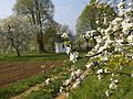
Cherry blossom at Walberla

Mittelbergwand in the Hirschbachtal


The 2007 km² Northern Franconian Alb is the northernmost part of the Franconian Alb. It is located in the Bavarian administrative districts of Upper Franconia , Middle Franconia (southwest) and Upper Palatinate (southeast), with the Upper Franconian districts taking up the majority.
Its north extends close to the Red Main or the Main between Bayreuth in the east, Lichtenfels in the north and Bamberg in the west, its southern west is flanked from Bamberg by the Regnitz , which, however, extends upstream to Nuremberg by up to 20 km from the Alb away.
The southern border to the Middle Franconian Alb roughly follows the federal highway 14 between Hersbruck and Sulzbach-Rosenberg , but deviates slightly to the north from this line in the east via Etzelwang and Neukirchen . It follows the river valleys of Pegnitz and Etzelbach , in the far east that of the Rosenbach .
To the east, the Northern Franconian Alb is flanked by the Vils about eight kilometers away .
- Landscapes and Places
Franconian Switzerland, named after its typical rock formations, is located in the center of the Northern Franconian Jura . South of this is the Dolomite Kuppenalb , while the south-west belonging to Middle Franconia is referred to as Hersbrucker Schweiz and is part of the Hersbrucker Alb , which is not a natural unit and continues in the north-west of the Middle Franconian Alb . In the south-east of the landscape between Pegnitz (N), Auerbach (O) and the A 9 (W) is the 107 km² large Veldenstein Forest, which is free from communes and almost entirely covered with coniferous forest .
The north-west near Bamberg belonged to the tertiary volcanic field of the Heldburg gang , which, however, is not visible in surface forms.
The Northern Franconian Alb is almost congruent with the 2346 square kilometer Franconian Switzerland-Veldenstein Forest Nature Park , which is located in the districts of Bamberg , Bayreuth , Forchheim , Kulmbach , Lichtenfels , Neustadt an der Waldnaab , Amberg-Sulzbach and Nürnberger Land .
Middle Franconian Alb

The 1778 km² Middle Franconian Alb connects the Northern and Southern Franconian Alb. It lies almost entirely in the Bavarian administrative district of Upper Palatinate and is therefore also known as the Upper Palatinate Alb (or Upper Palatinate Jura ). Only the extreme northwest is in Central Franconia .
Its northern border with the Northern Franconian Alb runs east of the Pegnitz River between Hersbruck and Sulzbach-Rosenberg ( see above ), to the west it is flanked by the Schwarzach and south of Neumarkt by the Ludwig-Danube-Main Canal .
Between Parsberg and Regensburg , the southwest border to the southern Franconian Alb follows roughly the Schwarzen Laber .
On the eastern edge are Amberg in the north and Schwandorf in the middle.
- Landscapes and Places
In the center of the Middle Franconian Alb in the district of Neumarkt in the Upper Palatinate lies the 149.02 km² military training area Hohenfels . To the north of this, in the district of Amberg-Sulzbach , which occupies the north-east of the landscape, the 277.59 km² Hirschwald Nature Park , which to the north just exceeds the Franconian Alb area.
The south-east is in the district of Schwandorf , the extreme southeast in the district of Regensburg and the west in the district of Neumarkt in the Upper Palatinate.
The north-west, which is still in the central Franconian district of Nürnberger Land , is largely counted as part of the Hersbrucker Alb , which, however, does not represent a natural spatial unit and continues north into the Northern Franconian Alb . The term Oberpfälzer Jura is also not limited to the Middle Franconian Jura and is also used for the south-east of the northern part. Both landscape names dive u. a. in the naming of nature reserves.
The east of the landscape is occupied by the Vilsplatten , which the Vils cuts south of Amberg .
Southern Franconian Alb
The 3126 square kilometer Southern Frankenalb is the southernmost part of the Franconian Jura. It continues the Swabian Alb east of the Nördlinger Ries in its east-northeast direction to about Regensburg . With Upper Palatinate (northeast), Lower Bavaria (southeast), Upper Bavaria (central south), Swabia (southwest) and Middle Franconia (western and central north), five of the seven Bavarian administrative districts have a share in the southern Franconian Alb .
Landscapes and Places
The southern Franconian Alb is essentially identical to the 2962.4 square kilometer Altmühltal Nature Park , which is located in the districts of Donau-Ries , Eichstätt , Kelheim , Neuburg-Schrobenhausen , Neumarkt in der Oberpfalz , Regensburg , Roth and Weißenburg-Gunzenhausen . However, the nature park crosses the borders of the Alb in the north-west, while in the east it does not quite reach the edge.
The landscape is cut in a west-east direction by the Altmühltal between Treuchtlingen and Kelheim , which is one of the valleys of the original Danube .
The two westernmost spurs of the eaves in the north of the landscape are called Hahnenkamm (between Wörnitz and Altmühl ) and Weißenburger Alb (between Altmühl and Schwarzach ).
Landscape names, protected areas and nature parks
The common landscape names of the Franconian Alb only partially designate natural spatial sub-units; many are more based on historical and tourist names.
The landscapes of the Franconian Alb, which are better known by name, include from north to southwest (larger protected areas may be listed as sub-items):
-
Northern Franconian Alb
-
Northern Franconian Jura , extreme north of the Northern Franconian Jura , districts of Lichtenfels , Bamberg and Kulmbach
- FFH area dry grassland, meadows and forests around Weismain (19.90 km², Lichtenfels district)
- multi-part bird sanctuary rock and hillside forests in the northern Franconian Jura (52.67 km²)
- Albtrauf (west, districts of Lichtenfels, Bamberg and Forchheim )
- multi-part FFH area Albtrauf in the district of Lichtenfels (18.53 km²)
- multi-part FFH area Albtrauf from Dörnwasserlos to Zeegendorf (30.63 km², Bamberg district)
- multi-part FFH area Albtrauf from the Friesener Warte to the Long Mile (18.86 km², districts of Bamberg and Forchheim)
- two-part FFH area Ehrenbürg and Katzenköpf (9.06 km², Forchheim district)
- multi-part FFH area orchards, head oaks and springs on the Hetzleser Berg (14.38 km², Forchheim district)
- Franconian Switzerland , central main part of the Northern Franconian Jura, districts Bamberg, Bayreuth and Forchheim
-
Dolomitkuppenalb , south of Franconian Switzerland; Forchheim, Nürnberger Land and Bayreuth districts
- three-part FFH area Dolomitkuppenalb (21.95 km², district of Nürnberger Land)
- Eastern edge
- FFH area US military training area Grafenwöhr (192.79 km², but only to a small extent in the northwest in the Franconian Alb; district Neustadt)
- FFH area Wellucker Forest north of Königstein (8.99 km², districts of Amberg-Sulzbach and Nürnberger Land)
-
Northern Franconian Jura , extreme north of the Northern Franconian Jura , districts of Lichtenfels , Bamberg and Kulmbach
- Transitional area between the Northern and Middle Franconian Alb
-
Hersbrucker Alb (Hersbrucker Switzerland), west of the transition region between Northern and Middle Frankenalb - term only in Nuremberg County used
- multi-part FFH area eaves slopes of the Hersbrucker Alb (14.72 km²)
- multi-part FFH area Bachtäler of the Hersbrucker Alb (6.98 km²)
-
Upper Palatinate Jura , east of the Northern and Middle Franconian Jura in the Amberg-Sulzbach district
- FFH area forests in the Upper Palatinate Jura (8.04 km²)
-
Hersbrucker Alb (Hersbrucker Switzerland), west of the transition region between Northern and Middle Frankenalb - term only in Nuremberg County used
-
Middle Franconian Alb
- FFH and bird sanctuary military training area Hohenfels (149.02 km², Neumarkt district )
- FFH area flanks of the Naab breakthrough valley between Kallmünz and Mariaort (14.41 km², district of Regensburg )
- multi-part FFH area Schwarze Laaber (11.59 km², district of Regensburg)
- Transitional area between the Middle and Southern Franconian Alb
- FFH area Weisse , Wissinger , Breitenbrunner Laaber and Kreuzberg near Dietfurt (23.23 km², district of Neumarkt)
- multi-part FFH area of the eaves of the central Franconian Alb in the Sulztal (12.24 km², Neumarkt district - in terms of natural space, despite the name, entirely in the southern Franconian Alb)
-
Southern Franconian Alb
- Eaves of the southern Franconian Alb (43.24 km², Weißenburger Alb and Hahnenkamm)
- Weißenburger Alb , spur on the eaves between Altmühl- (W) and Schwarzach valley (O) near Weißenburg
-
Altmuehltal
- multi-part bird sanctuary rocks and hillside forests in the Altmühltal and Wellheimer dry valley (36.11 km²)
- Eichstätter Alb , southern Franconian Alb in the Altmühltal near Eichstätt
- Bird sanctuary Altmühltal with Brunst-Schwaigau and Altmühlsee (50.03 km², but only to a southeastern fraction in the Franconian Alb; district of Weißenburg-Gunzenhausen )
- multi-part FFH area Mittleres Altmühltal with Wellheimer dry valley and Schambach valley (42.05 km²)
- Hahnenkamm , mountain ridge on the western eaves between Wörnitz - (W) and Altmühltal (O); Weissenburg-Gunzenhausen district
- South of the southern Franconian Alb
- two-part FFH area (partly NSG ) Hienheimer Forst east and west of Swabia (11.89 km², east, district of Kelheim )
- FFH area Donauwörther Forest with training area and Harburger Karab (24.01 km², west, district of Donau-Ries )
- Nature parks
Nature parks in the Franconian Alb are:
- Franconian Switzerland-Veldenstein Forest Nature Park , largely congruent with the Northern Franconian Alb
- Deer Forest Nature Park , north of the middle of the Middle Franconian Jura, Amberg-Sulzbach district
- Altmühltal Nature Park , largely congruent with the Southern Franconian Alb
mountains
The mountains of the Franconian Alb and their most important witness mountains include - sorted by height in meters (m) above sea level :
Abbreviations used in the table below illustrates.
| mountain | Height (m) |
landscape | Main unit | location |
agriculture circle |
|---|---|---|---|---|---|
| ( Hesselberg ) | 689.4 | Zeugenberg north-west. the SFA | Foreland of the SFA | Ehingen / Gerolfingen | ON |
| Dürrenberg | 656.4 | Cockscomb | Southern FA | Heidenheim | WUG |
| Poppberg | 652.6 | Upper Palatinate Jura | Medium FA | Birgland | AS |
| Ossinger | 651.1 | Upper Palatinate Jura | Northern FA | Koenigstein | AS |
| Kappersberg | 650.7 | Upper Palatinate Jura | Medium FA | Birgland - Frechetsfeld | AS |
| Kütschenrainberg | 647 | northeastern NFA | Northern FA | Kirchenthumbach / Heinersreuther Forest | NEW |
| Zantberg | 646.8 | Upper Palatinate Jura | Northern FA | Hirschbach / Neukirchen | AS |
| Limpelberg | 640.9 | southern MFA | Medium FA | Parsberg - Holzheim / Velburg - Freudenricht | NM |
| High Reut | 635 | Dolomitkuppenalb | Northern FA | Betzenstein - Riegelstein | BT |
| Yellow mountain | 628.4 | Cockscomb | Southern FA | Dittenheim - Sammenheim | WUG |
| Little Kulm | 627 | Franconian Switzerland | Northern FA | Basket village | BT |
| Hohenstein | 624 | Hersbrucker Switzerland | Northern FA | Kirchensittenbach - Hohenstein | LAU |
| Goeschberg | 620.6 | northeastern SFA | Southern FA | Seubersdorf / Deining | NM |
| Wülzburger Berg | 620 | Weissenburger Alb | Southern FA | Weissenburg | WUG |
| ( Schlossberg ) | 606.7 | Zeugenberg north of the SFA | Foreland of the SFA | Heideck | RH |
| ( Moritzberg ) | 603.5 | Zeugenberg west of the Hersbrucker Alb | Foreland of the NFA | Röthenbach - Moritzberg / Leinburg / Lauf - Weigenhofen | LAU |
| Great Hansgörgl | 601 | Eaves of the Hersbrucker Alb | Medium FA | Reichenschwand | LAU |
| ( Dillberg ) | 595 | Zeugenberg west of the MFA | Foreland of the MFA | Postbauer-Heng - Dillberg | NM |
| ( Buchberg ) | 591 | Zeugenberg west of the MFA | Foreland of the MFA | Neumarkt / Berngau / Sengenthal - Buchberg | NM |
| Ottenberg | 588.0 | Nightmare of the MFA | Medium FA | Pilsach / Berg | NM |
| Neubürg | 586.8 | Eastern edge of the NFA | Northern FA | Mistelgau - residential area | BT |
| Geisberg | 585 | Eaves of the NFA | Northern FA | Geisberger Forest | BA |
| Kemitzenstein | 580.6 | Northern Franconian Jura | Northern FA | Bad Staffelstein - Kümmersreuth | LIF |
| Bald stone | 572 | Hersbrucker Switzerland | Northern FA | Neunkirchen - Weißenbach | LAU |
| Friesener Warte | 561.7 | Eaves of the NFA | Northern FA | Hirschaid - Friesen / Buttenheim - Kälberberg | BA |
| Reisberg | 553.9 | Northern Franconian Jura | Northern FA | Schlappenreuth | BA |
| Little Hansgörgl | 553 | Eaves of the Hersbrucker Alb | Medium FA | Reichenschwand | LAU |
| Lindenberg | 545 | Eaves of the NFA | Northern FA | Neunkirchen - Ermreuth / Oberlindelbach | FO |
| Schlossberg | 543 | Franconian Switzerland | Northern FA | Pegnitz | BT |
| ( Flüglinger Berg ) | 541.3 | Zeugenberg north of the SFA | Foreland of the SFA | Weißenburg - Weimersheim | WUG |
| Staffelberg | 540 | Northern Franconian Jura | Northern FA | Bad Staffelstein | LIF |
| Kordigast | 538.1 | Northern Franconian Jura | Northern FA | Altenkunstadt | LIF |
| Rodenstein ( honorary citizen ) | 531.7 | Eaves / Zeugenberg of the NFA | Northern FA | Wiesenthau / Leutenbach | FO |
| Arzberg | 507.1 | Eichstätter Alb at the Altmühltal | Southern FA | Beilngries | EGG |
| Schellenberg | 494.5 | Eichstätter Alb at the Altmühltal | Southern FA | Enkering | EGG |
Abbreviations in the table stand for:
- FA = Franconian Alb
- MFA = Middle Franconian Alb
- NFA = Northern Franconian Alb
- SFA = Southern Franconian Alb
- Counties as license plates
tourism
Of particular tourist interest is the Northern Franconian Alb, Franconian Switzerland , which has numerous rock formations. The Altmühltal in the southern Franconian Jura also gained tourist importance with side valleys with rocks washed out by the Primeval Danube as a “climbing paradise” and with continuous cycle paths. The Altmühltal and the Northern Franconian Jura are among the more important climbing areas in Germany and are internationally known among sport climbers.
Numerous castles and small towns are worth seeing. The hiking trails are marked and maintained on a voluntary basis by associations such as the Franconian Alb Association and the Franconian Switzerland Association .
The districts of Amberg-Sulzbach, Neumarkt in der Oberpfalz, Regensburg (western part) and Kelheim are marketed by Tourismusmarketing Ostbayern GmbH under the art term Bavarian Jura .
geology
The Franconian Alb is the geological continuation of the Swiss Jura and the Swabian Alb to the east.
During the entire Jurassic period , about 161 to 150 million years ago, the whole of southern Germany was in the area of a shallow sea, when, due to the constant subsidence of the earth's crust, massive rock sequences were deposited on the sea floor. The Jura sediments still form the largest part of the rock, mainly limestone , and are the basic material of the Franconian Alb.
The sea retreated due to uplifts of the European continental plate towards the end of the Upper Jurassic and larger areas became mainland at the beginning of the following Cretaceous period. During this time there was a tropical climate and intensive weathering of the limestone and dolomite rocks that had previously formed.
In the time of the Upper Cretaceous a sea again advanced into the area of the Franconian Alb.
In the Tertiary , the sea receded again due to regional uplift and the Jura landscape was partially exposed.
The Franconian Alb is rich in beautiful rocks , caves , sinkholes , karst springs and stone channels . It is traversed by some deeply cut rivers and streams and by dry valleys. The dry grass slopes of the southern Alb are a special biological feature .
References and comments
- ↑ a b c Map services of the Federal Agency for Nature Conservation ( information )
- ↑ a b The Hesselberg ( 689.4 m ), which extends the line of the Hahnenkamm to the northwest, lies outside the Franconian Alb, but extends the direction of the Hahnenkamm to the west-northwest. It is sometimes listed as the highest elevation of the Franconian Alb, but lies well outside the same in the foreland of the Southern Franconian Alb ( Franconian Keuper-Lias-Land ). Its mountain height is mentioned without any indication of the height reference according to the information board on the Hesselberg path photographed in 2005 .
- ^ Emil Meynen , Josef Schmithüsen (Ed.): Handbook of the natural spatial structure of Germany . Federal Institute for Regional Studies, Remagen / Bad Godesberg 1953–1962 (9 deliveries in 8 books, updated map 1: 1,000,000 with main units 1960).
-
↑ Map services of the Federal Agency for Nature Conservation ( information )
- Map service landscapes shows the boundaries of individual partial landscapes and makes landscape profiles with area information (80xxx = northern, 81xxx = middle, 82xxx = southern Franconian Alb) clickable
- Map service for protected areas shows mountain heights down to TK 25;
Nature reserves, FFH areas, nature parks (each with area information), main units and communal boundaries can be displayed
-
^ Definition of the Hahnenkamm and above all the Weißenburger Alb according to:
Emil Meynen and Josef Schmithüsen : Handbook of the natural spatial structure of Germany (second delivery) - Federal Institute for Regional Studies, Remagen 1955 - ↑ The almost equally high east-southeast of the ridge of the Kütschenrainberg is called Kalvarienberg
- ↑ The height above sea level (NHN) from the Wülzburger Berg ( 620 m ) should not be confused with the platform height of the Roßmühle bastion ( 643.8 m ), which is part of the Wülzburg fortress there (both heights according to the individual evidence of the BfN map services ).
- ↑ The Ehrenbürg is basically a witness mountain of the Northern Franconian Alb and separated from the actual Alb by the valley of the Ehrenbaches ; nevertheless, the demarcation in the handbook of the natural division of Germany still counts him as part of the Franconian Jura and not its foreland.
literature
- Hans Sperber: Geological-botanical forays through northeast Bavaria. Upper Franconian Publishing House and Printing House, Hof 1979, ISBN 3-921615-27-5 .
- Irene Reif : "Nightmares". The Franconian Alb. In: Franconia - my love. Oberfränkische Verlagsanstalt, Hof 1989, ISBN 3-921615-91-7 , p. 127f.
- Federal Agency for Nature Conservation (Hrsg.): Future of low mountain range landscapes: Scenarios for the development of rural areas using the example of the Franconian Alb. Landwirtschaftsverlag, Münster 2002, ISBN 3-7843-3820-8 .
- Max Schäfer: Hiking with children in the Franconian Jura. A book for young parents and grandparents 3. updated, redesigned and heavily expanded. Edition. Tümmel, Nuremberg 1999, ISBN 3-921590-71-X .
- Hanns Zischler : The most beautiful lunar landscape you can imagine: the Franconian Alb. In: German Landscapes. S. Fischer Verlag 2003, ISBN 3-10-070404-5 , pp. 293-303.
cards
- Fritsch cards: No. 65, Franconian Switzerland Nature Park. ISBN 3-86116-065-X
No. 53, sheet south, Veldensteiner Forst, Hersbrucker Alb. ISBN 3-86116-053-6
No. 72, Hersbrucker Alb in the Frankenalb, Pegnitz- and Hirschbachtal. ISBN 3-86116-072-2 .
Web links