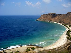
Fatu Cama Bay
| Fatu Cama Bay | ||
|---|---|---|
|
View from Cape Fatu Cama over the bay |
||
| Waters | Wetar Strait | |
| Land mass | Timor | |
| Geographical location | 8 ° 31 '12 " S , 125 ° 36' 51" E | |
|
|
||
|
Map of the administrative office of Cristo Rei with the bay to the north |
||
The bay of Fatu Cama (also Fatocama ) is located on the Strait of Wetar , on the north coast of the island of Timor .
geography
The bay of Fatu Cama is located in the East Timorese municipality of Dili , east of the capital of the same name between Cape Fatu Cama in the west and the Ponta Fatossídi . The beach is called Dolok Oan . The area is the northwesternmost point of the Sucos Hera ( administrative office of Cristo Rei ).
The bay belongs to the Important Bird Area and the Areia Branca Wildlife Sanctuary .
The bay of Fatu Cama from the sea
Individual evidence
- ↑ Geoview: Teluk Fatocama , accessed January 29, 2016.
- ↑ Birdlife International: Areia Branca no Dolok Oan , accessed January 28, 2016.


