Burgersfort
| Burgersfort | ||
|---|---|---|
|
|
||
| Coordinates | 24 ° 40 '53 " S , 30 ° 20' 6" O | |
| Basic data | ||
| Country | South Africa | |
| Limpopo | ||
| District | Sekhukhune | |
| ISO 3166-2 | ZA-LP | |
| local community | Fetakgomo / Greater Tubatse | |
| height | 755 m | |
| surface | 28.1 km² | |
| Residents | 6369 (2011) | |
| density | 226.7 Ew. / km² | |
|
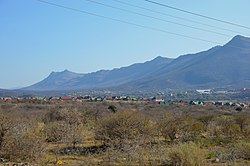
Panorama of Burgersfort
|
||
Burgersfort ( Afrikaans / English; German for example: " Burgers' Fort") is a city in the South African province of Limpopo . It was the administrative seat of the Greater Tubatse municipality in the Sekhukhune district, which was dissolved in 2016 .
geography
In 2011, Burgersfort had 6,369 inhabitants (2011 census). The city lies in the valley of the Spekboom River, a tributary of the Steelpoort River (also Tubatse), and on the northern edge of the Bushveld complex , which has a high content of platinum and other platinum metals .
history
The place was named after a fort that was built in 1876/1877 in the fight against the Bapedi ruler Sekhukhune and was located in the place. The fort was named after a President of the South African Republic (CAR), Thomas François Burgers .
Economy and Transport
Platinum is won at Burgersfort. The R37 connects Polokwane in the north via Burgersfort with Mashishing in the south. The R555 runs roughly at right angles to Middelburg in the southwest and Ohrigstad in the east. In terms of freight traffic, Burgersfort is served on the eMakhazeni - Steelpoort branch line.
Web links
- Portrait at sa-venues.com (English)
Individual evidence
- ↑ 2011 census , accessed on August 10, 2017

