Bystry Tanyp
|
Bystry Tanyp Бы́стрый Таны́п, Тере Танып, Tanyp |
||
|
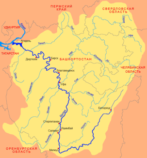
Location of the Bystry Tanyp (Таны́п) in the catchment area of the Belaja |
||
| Data | ||
| Water code | RU : 10010201612111100025674 | |
| location | Perm Region , Bashkortostan ( Russia ) | |
| River system | Volga | |
| Drain over | Belaya → Kama → Volga → Caspian Sea | |
| source | in the Tulvinskaya Heights 56 ° 43 ′ 29 ″ N , 56 ° 6 ′ 32 ″ E |
|
| muzzle | in the Belaja coordinates: 55 ° 42 '18 " N , 54 ° 33' 26" E 55 ° 42 '18 " N , 54 ° 33' 26" E
|
|
| length | 345 km | |
| Catchment area | 7560 km² | |
| Outflow location: 20 km above the mouth |
MQ |
44.5 m³ / s |
| Medium-sized cities | Chernushka | |
The Bystry Tanyp , also just Tanyp ( Russian Бы́стрый Таны́п , Bashkir Тере Танып ) is a right tributary of the Belaja in the Perm region and in Bashkortostan in the European part of Russia .
It has its source in the Tulvinskaya Heights in the south of the Perm region. It initially flows in a southerly direction past the city of Chernushka to Bashkortostan, then turns west. He finally meets the Belaja, which he reaches 115 km before its confluence with the Kama on the right. The Bystry Tanyp has numerous meanders in the lower reaches . The 345 km long river drains an area of 7560 km². It is covered with ice between the beginning of November and April. The mean discharge of the Bystry Tanyp is 44.5 m³ / s 20 kilometers above the mouth.
Individual evidence
- ↑ a b c d e Article Bystry Tanyp in the Great Soviet Encyclopedia (BSE) , 3rd edition 1969–1978 (Russian)
- ↑ a b Bystry Tanyp in the State Water Register of the Russian Federation (Russian)
