Cöthener river valley
|
Cöthener river valley
|
||
|
Cöthener Fliess |
||
| location | Brandenburg , Germany | |
| surface | 75 ha | |
| WDPA ID | 555518725 | |
| Natura 2000 ID | DE3249301 | |
| Geographical location | 52 ° 48 ' N , 13 ° 56' E | |
|
|
||
| Sea level | from 24 m to 82 m | |
| Setup date | 2003 | |
| administration | State Environment Agency Brandenburg Department of Ecology, Nature Conservation, Water | |
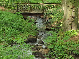
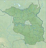
The Cöthener Fließal (also Cöthener Park ) is a tourist and nature conservation area of around 75 hectares on the border between the Barnim and the old Oder valley in northeast Brandenburg in the northeast of Berlin .
The Cöthener Fließal got its name from the Cöthener Fließ (also "Falkenberger Fließ"). It includes its headwaters in the hilly foothills of the Barnim as well as the stream down to the town of Falkenberg , from where the river flows into the open Oderbruch and then into the old Oder.
Geology, flora and fauna
Formed during the Vistula Ice Age, the Cöthener Fliess is characterized by strongly relieved compression terminal moraine formations. The predominantly forested area is very diverse in terms of plant sociology in the source area of the alder and ash forest , which is characterized by hillside moor , and the oak and hornbeam forest below . There are also beech and sycamore maple as well as pine , larch and robinia from other sites . The Cöthener Fließ is home to a number of rare insect, bird and bat species, especially the protected species
- large mouse-eared mouse (Myotis myotis),
- Pug Bat (Barbastella barbastellus) and
- Hermit (Osmoderma eremita).
Recent history and tourist use
At the beginning of the 19th century, the Cöthener Fließal was designed as a landscape park on behalf of Carl Friedrich von Jena , which was located in the immediate vicinity of the Cöthener Castle, which was built at the same time. The remains of the park - the restored water wheel, an artificial waterfall and the Carlsburg hunting lodge - give the area its present-day appearance, which is characterized by natural hiking trails and excursion destinations.
Protection status
In 1996, the Märkisch-Oderland district was given the authority to designate a protected area in the Cöthener Fließ area. From then on, the area was listed in documents and maps as a nature reserve . led in the proceedings . However, the project has since been abandoned.
In 2003, the area became part of the Europe-wide Natura2000 protected area as a flora-fauna-habitat protection area .
A corresponding management plan has been in place since 2014. This describes specific protective measures and provides for the protection to be achieved by establishing it as a nature reserve and foregoing a management decree.
In December 2017, the protection status of the Cöthener Fließ was confirmed by ordinance by the Brandenburg State Office for the Environment as an area of community importance, without any specific protective measures being adopted.
To date, no specific protective measures have therefore been legally stipulated, despite the recognized need.
Economic use
The Cöthener Fließ is used for timber, especially after it was sold by the BVVG to private owners in 2016. This commercial use is in tension with the legal mandate to maintain or restore.
Individual evidence
- ↑ a b L. Lippstreu, N. Hermsdorf, A. Sonntag: Geological overview map of the state of Brandenburg 1: 300,000 - explanations . Potsdam 1997, ISBN 3-7490-4576-3 .
- ↑ a b c d e Management plan for the areas "Hutelandschaft Altranft-Sonnenburg", "Cöthener Fließal" and "Oderbruchrand Bad Freienwalde" . In: Ministry for the Environment, Health and Consumer Protection of the State of Brandenburg (Ed.): Management planning Natura 2000 in the State of Brandenburg . Potsdam July 2014 ( brandenburg.de [PDF; accessed October 26, 2019]).
- ↑ First ordinance for the transfer of the power to issue statutory ordinances for the establishment of nature reserves and landscape protection areas. January 8, 1996, accessed February 9, 2020 .
- ↑ Information by email dated November 4, 2019 from the Märkisch-Oderland district, Office for Agriculture and Environment, Lower Nature Conservation Authority, Puschkinallee 12, 15306 Seelow.
- ^ Fifteenth ordinance on the establishment of conservation objectives and area delimitations for areas of Community importance (15th Conservation Objectives Ordinance - 15th ErhZV) . December 18, 2017 ( brandenburg.de [accessed October 26, 2019]).


